Nanyi geodata
Nanyi (Jiangxi) is a seat of a fourth-order administrative division; located in China in Asia/Shanghai (GMT+8) time zone. In our database, there are 1268 cities with bigger population. Compared to other cities in China, 60.4% of cities are located further ↑North; 55.9% of cities are located further ←West and 64.8% of cities have higher elevation than Nanyi. Note1


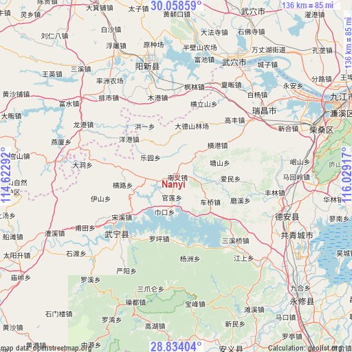
Nanyi GPS coordinates[2]
29° 26' 53.376" North, 115° 19' 33.744" East
| Map corner | latitude | longitude |
|---|---|---|
| Upper-left | 30.05859°, | 114.62292° |
| Center: | 29.44816°, | 115.32604° |
| Lower-right: | 28.83404°, | 116.02917° |
| Map W x H: | 136.2×136.2 km | = 84.6×84.6mi |
| max Lat: | 53.31946° ⇑60.4% North |
| Nanyi: | 29.44816° |
| min Lat: | ⇓39.6% South 18.22056° |
| min Long | Nanyi | max Long |
| 75.07348° | 115.32604° | 134.28917° |
| W 55.9%⇐ | ⇒44.1% E |
Elevation
Elevation of Nanyi is 74 m = 243 ft, and this is 410.8 m = 1348 ft below average elevation for this country.
| Max E: |
5622 m = 18445 ft | 64.8% |
| Avg. | 484.8 m = 1591 ft | |
| Nanyi | 74 m = 243 ft | |
Min E: |
-3 m = -10 ft | 35.2% |
See also: China elevation on elevation.city.
Geographical zone
Nanyi is located in North temperate zone (between Tropic of Cancer and the Arctic Circle). Distance of this Northern Tropic circle is 668.4 km =415.3 mi to South.| Distance of | km | miles | from Nanyi |
|---|---|---|---|
| North Pole | 6732.7 | 4183.5 | to North |
| Arctic Circle | 4126.8 | 2564.3 | to North |
| Tropic Cancer | 668.4 | 415.3 | to South |
| Equator | 3274.3 | 2034.6 | to South |


Nearby cities:
15 places around Nanyi: (largest is in red/bold)
• Aimin
20.9 km =13 mi,  92°
92°
• Cheqiao
16.3 km =10.1 mi,  126°
126°
• Guanlian
8.2 km =5.1 mi,  188°
188°
• Henggang
19.8 km =12.3 mi,  52°
52°
• Henglu
21.3 km =13.2 mi,  260°
260°
• Hongyi
23.1 km =14.4 mi,  327°
327°
• Huayuan
16.5 km =10.3 mi,  358°
358°
• Leshan
21.5 km =13.4 mi,  41°
41°
• Leyuan
12.7 km =7.9 mi,  305°
305°
• Luoping
25 km =15.5 mi,  195°
195°
• Luxi
9.1 km =5.7 mi, 260°
• Tangshan
17.4 km =10.8 mi,  72°
72°
• Yanggang
23.3 km =14.5 mi, 308°
• Zhaochen
20.2 km =12.6 mi,  317°
317°
• Zouqiao
15.7 km =9.8 mi,  99°
99°
Sources, notices
• [Note1] Compared only with cities in China existing in our database
• [Src1] Map data: © OpenStreetMap contributors (CC-BY-SA)
• [Src2] Other city data from geonames.org with taken over terms of usage.
• [Src3] Geographical zone / Annual Mean Temperature by Robert A. Rohde @ Wikipedia
