Longtan geodata
Longtan (Hunan) is a seat of a fourth-order administrative division; located in China in Asia/Shanghai (GMT+8) time zone. In our database, there are 1268 cities with bigger population. Compared to other cities in China, 65.8% of cities are located further ↑North; 66.5% of cities are located further →East and 55.9% of cities have higher elevation than Longtan. Note1


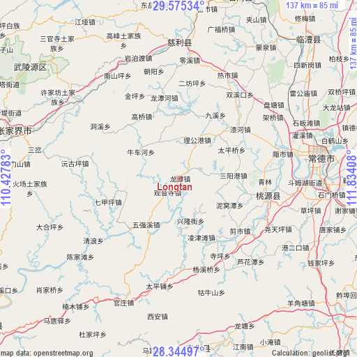
Longtan GPS coordinates[2]
28° 57' 43.128" North, 111° 7' 51.42" East
| Map corner | latitude | longitude |
|---|---|---|
| Upper-left | 29.57534°, | 110.42783° |
| Center: | 28.96198°, | 111.13095° |
| Lower-right: | 28.34497°, | 111.83408° |
| Map W x H: | 136.8×136.8 km | = 85×85mi |
| max Lat: | 53.31946° ⇑65.8% North |
| Longtan: | 28.96198° |
| min Lat: | ⇓34.2% South 18.22056° |
| min Long | Longtan | max Long |
| 75.07348° | 111.13095° | 134.28917° |
| W 33.5%⇐ | ⇒66.5% E |
Elevation
Elevation of Longtan is 125 m = 410 ft, and this is 359.8 m = 1180 ft below average elevation for this country.
| Max E: |
5622 m = 18445 ft | 55.9% |
| Avg. | 484.8 m = 1591 ft | |
| Longtan | 125 m = 410 ft | |
Min E: |
-3 m = -10 ft | 44.1% |
See also: China elevation on elevation.city.
Geographical zone
Longtan is located in North temperate zone (between Tropic of Cancer and the Arctic Circle). Distance of this Northern Tropic circle is 614.4 km =381.8 mi to South.| Distance of | km | miles | from Longtan |
|---|---|---|---|
| North Pole | 6786.8 | 4217.1 | to North |
| Arctic Circle | 4180.9 | 2597.9 | to North |
| Tropic Cancer | 614.4 | 381.8 | to South |
| Equator | 3220.3 | 2001 | to South |


Nearby cities:
15 places around Longtan: (largest is in red/bold)
• Canmang
23.7 km =14.7 mi,  258°
258°
• Gaoqiao
27.4 km =17 mi,  329°
329°
• Guanyinsi
6.7 km =4.2 mi,  220°
220°
• Huangjiapu
22.7 km =14.1 mi,  42°
42°
• Huangshi
25.3 km =15.7 mi,  14°
14°
• Jiuxi
27.9 km =17.3 mi,  29°
29°
• Ligonggang
16.3 km =10.1 mi,  24°
24°
• Nanmu
23.4 km =14.5 mi,  247°
247°
• Niuchehe
18 km =11.2 mi,  302°
302°
• Qijiaping
28.3 km =17.6 mi, 252°
• Sanyanggang
21 km =13 mi,  85°
85°
• Shejiaping
11.9 km =7.4 mi,  81°
81°
• Shenshuigang
26.5 km =16.5 mi,  101°
101°
• Taipingqiao
22.9 km =14.2 mi,  61°
61°
• Zhongjiapu
16.2 km =10.1 mi, 330°
Sources, notices
• [Note1] Compared only with cities in China existing in our database
• [Src1] Map data: © OpenStreetMap contributors (CC-BY-SA)
• [Src2] Other city data from geonames.org with taken over terms of usage.
• [Src3] Geographical zone / Annual Mean Temperature by Robert A. Rohde @ Wikipedia
