Gaoqiao geodata
Gaoqiao (Hunan) is a seat of a fourth-order administrative division; located in China in Asia/Shanghai (GMT+8) time zone. In our database, there are 1268 cities with bigger population. Compared to other cities in China, 63.5% of cities are located further ↑North; 67% of cities are located further →East and 58.7% of cities have lower elevation than Gaoqiao. Note1


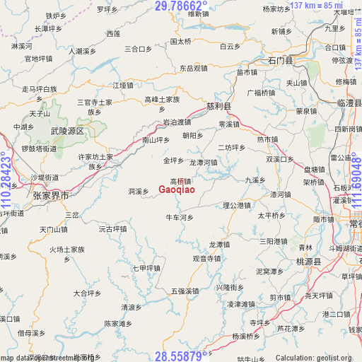
Gaoqiao GPS coordinates[2]
29° 10' 28.344" North, 110° 59' 14.46" East
| Map corner | latitude | longitude |
|---|---|---|
| Upper-left | 29.78662°, | 110.28423° |
| Center: | 29.17454°, | 110.98735° |
| Lower-right: | 28.55879°, | 111.69048° |
| Map W x H: | 136.5×136.5 km | = 84.8×84.8mi |
| max Lat: | 53.31946° ⇑63.5% North |
| Gaoqiao: | 29.17454° |
| min Lat: | ⇓36.5% South 18.22056° |
| min Long | Gaoqiao | max Long |
| 75.07348° | 110.98735° | 134.28917° |
| W 33%⇐ | ⇒67% E |
Elevation
Elevation of Gaoqiao is 244 m = 801 ft, and this is 240.8 m = 790 ft below average elevation for this country.
| Max E: |
5622 m = 18445 ft | 41.3% |
| Avg. | 484.8 m = 1591 ft | |
| Gaoqiao | 244 m = 801 ft | |
Min E: |
-3 m = -10 ft | 58.7% |
See also: China elevation on elevation.city.
Geographical zone
Gaoqiao is located in North temperate zone (between Tropic of Cancer and the Arctic Circle). Distance of this Northern Tropic circle is 638 km =396.4 mi to South.| Distance of | km | miles | from Gaoqiao |
|---|---|---|---|
| North Pole | 6763.2 | 4202.5 | to North |
| Arctic Circle | 4157.3 | 2583.2 | to North |
| Tropic Cancer | 638 | 396.4 | to South |
| Equator | 3243.9 | 2015.7 | to South |


Nearby cities:
15 places around Gaoqiao: (largest is in red/bold)
• Chaoyang
18.3 km =11.4 mi,  13°
13°
• Dongxi
16.2 km =10.1 mi,  257°
257°
• Ganyan
23.3 km =14.5 mi,  299°
299°
• Huangshi
20.2 km =12.6 mi,  87°
87°
• Jinglongqiao
17.8 km =11.1 mi,  36°
36°
• Jinping
8.5 km =5.3 mi,  340°
340°
• Ligonggang
22.6 km =14 mi,  113°
113°
• Longtanhe
11.5 km =7.1 mi,  48°
48°
• Nanshanping
18.3 km =11.4 mi,  330°
330°
• Niuchehe
14.1 km =8.8 mi,  184°
184°
• Wangjiaping
22.1 km =13.7 mi,  229°
229°
• Xikou
23 km =14.3 mi,  284°
284°
• Yanbodu
22.3 km =13.9 mi,  355°
355°
• Yichongqiao
21.3 km =13.2 mi,  324°
324°
• Zhongjiapu
11.3 km =7 mi,  147°
147°
Sources, notices
• [Note1] Compared only with cities in China existing in our database
• [Src1] Map data: © OpenStreetMap contributors (CC-BY-SA)
• [Src2] Other city data from geonames.org with taken over terms of usage.
• [Src3] Geographical zone / Annual Mean Temperature by Robert A. Rohde @ Wikipedia
