Nanmu geodata
Nanmu (Hunan) is a seat of a fourth-order administrative division; located in China in Asia/Shanghai (GMT+8) time zone. In our database, there are 1268 cities with bigger population. Compared to other cities in China, 66.6% of cities are located further ↑North; 67.4% of cities are located further →East and 60.6% of cities have lower elevation than Nanmu. Note1


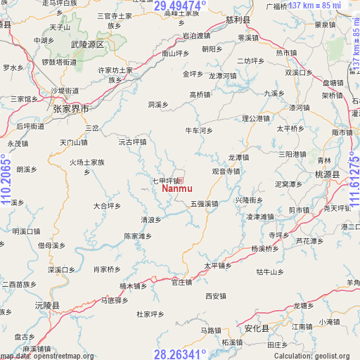
Nanmu GPS coordinates[2]
28° 52' 51.24" North, 110° 54' 34.632" East
| Map corner | latitude | longitude |
|---|---|---|
| Upper-left | 29.49474°, | 110.2065° |
| Center: | 28.8809°, | 110.90962° |
| Lower-right: | 28.26341°, | 111.61275° |
| Map W x H: | 136.9×136.9 km | = 85.1×85.1mi |
| max Lat: | 53.31946° ⇑66.6% North |
| Nanmu: | 28.8809° |
| min Lat: | ⇓33.4% South 18.22056° |
| min Long | Nanmu | max Long |
| 75.07348° | 110.90962° | 134.28917° |
| W 32.6%⇐ | ⇒67.4% E |
Elevation
Elevation of Nanmu is 267 m = 876 ft, and this is 217.8 m = 715 ft below average elevation for this country.
| Max E: |
5622 m = 18445 ft | 39.4% |
| Avg. | 484.8 m = 1591 ft | |
| Nanmu | 267 m = 876 ft | |
Min E: |
-3 m = -10 ft | 60.6% |
See also: China elevation on elevation.city.
Geographical zone
Nanmu is located in North temperate zone (between Tropic of Cancer and the Arctic Circle). Distance of this Northern Tropic circle is 605.3 km =376.1 mi to South.| Distance of | km | miles | from Nanmu |
|---|---|---|---|
| North Pole | 6795.8 | 4222.7 | to North |
| Arctic Circle | 4189.9 | 2603.5 | to North |
| Tropic Cancer | 605.3 | 376.1 | to South |
| Equator | 3211.3 | 1995.4 | to South |


Nearby cities:
15 places around Nanmu: (largest is in red/bold)
• Canmang
4.6 km =2.9 mi,  338°
338°
• Chenjiatan
26.9 km =16.7 mi,  215°
215°
• Dongxi
30.2 km =18.8 mi, 344°
• Gaoqiao
33.5 km =20.8 mi,  13°
13°
• Guanyinsi
17.6 km =10.9 mi,  77°
77°
• Huangrangping
23.7 km =14.7 mi,  158°
158°
• Longtan
23.4 km =14.5 mi,  67°
67°
• Niuchehe
19.7 km =12.2 mi,  18°
18°
• Qijiaping
5.5 km =3.4 mi,  274°
274°
• Qijiaxi
25.5 km =15.8 mi, 266°
• Shuangxiqiao
30.8 km =19.1 mi,  301°
301°
• Wangjiaping
20.4 km =12.7 mi,  333°
333°
• Xiejiaya
26.2 km =16.3 mi, 295°
• Yuanguping
23.4 km =14.5 mi,  309°
309°
• Zhongjiapu
26.9 km =16.7 mi,  30°
30°
Sources, notices
• [Note1] Compared only with cities in China existing in our database
• [Src1] Map data: © OpenStreetMap contributors (CC-BY-SA)
• [Src2] Other city data from geonames.org with taken over terms of usage.
• [Src3] Geographical zone / Annual Mean Temperature by Robert A. Rohde @ Wikipedia
