Jianlong geodata
Jianlong (Chongqing) is a seat of a fourth-order administrative division; located in China in Asia/Shanghai (GMT+8) time zone. In our database, there are 1268 cities with bigger population. Compared to other cities in China, 61.2% of cities are located further ↑North; 86.2% of cities are located further →East and 61.5% of cities have lower elevation than Jianlong. Note1


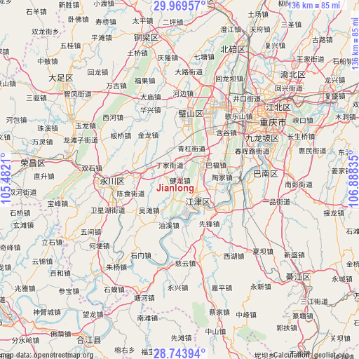
Jianlong GPS coordinates[2]
29° 21' 30.96" North, 106° 11' 6.792" East
| Map corner | latitude | longitude |
|---|---|---|
| Upper-left | 29.96957°, | 105.4821° |
| Center: | 29.3586°, | 106.18522° |
| Lower-right: | 28.74394°, | 106.88835° |
| Map W x H: | 136.3×136.3 km | = 84.7×84.7mi |
| max Lat: | 53.31946° ⇑61.2% North |
| Jianlong: | 29.3586° |
| min Lat: | ⇓38.8% South 18.22056° |
| min Long | Jianlong | max Long |
| 75.07348° | 106.18522° | 134.28917° |
| W 13.8%⇐ | ⇒86.2% E |
Elevation
Elevation of Jianlong is 276 m = 906 ft, and this is 208.8 m = 685 ft below average elevation for this country.
| Max E: |
5622 m = 18445 ft | 38.5% |
| Avg. | 484.8 m = 1591 ft | |
| Jianlong | 276 m = 906 ft | |
Min E: |
-3 m = -10 ft | 61.5% |
See also: China elevation on elevation.city.
Geographical zone
Jianlong is located in North temperate zone (between Tropic of Cancer and the Arctic Circle). Distance of this Northern Tropic circle is 658.5 km =409.2 mi to South.| Distance of | km | miles | from Jianlong |
|---|---|---|---|
| North Pole | 6742.7 | 4189.7 | to North |
| Arctic Circle | 4136.8 | 2570.5 | to North |
| Tropic Cancer | 658.5 | 409.2 | to South |
| Equator | 3264.4 | 2028.4 | to South |


Nearby cities:
15 places around Jianlong: (largest is in red/bold)
• Da’an
16.7 km =10.4 mi,  279°
279°
• Degan
10 km =6.2 mi,  153°
153°
• Dingjia
7 km =4.3 mi,  323°
323°
• Guangpu
4.6 km =2.9 mi,  236°
236°
• Jijiang
9.9 km =6.2 mi,  140°
140°
• Longhua
16.6 km =10.3 mi,  172°
172°
• Qinggang
13.1 km =8.1 mi,  22°
22°
• Sanhe
8.3 km =5.2 mi,  262°
262°
• Shuangfu
10.3 km =6.4 mi,  53°
53°
• Taojia
13.3 km =8.3 mi,  82°
82°
• Wutan
16.4 km =10.2 mi,  226°
226°
• Xipeng
15 km =9.3 mi,  118°
118°
• Youxi
17.1 km =10.6 mi,  193°
193°
• Zhengxing
12.3 km =7.6 mi,  333°
333°
• Zouma
16.4 km =10.2 mi,  40°
40°
Sources, notices
• [Note1] Compared only with cities in China existing in our database
• [Src1] Map data: © OpenStreetMap contributors (CC-BY-SA)
• [Src2] Other city data from geonames.org with taken over terms of usage.
• [Src3] Geographical zone / Annual Mean Temperature by Robert A. Rohde @ Wikipedia
