Jijiang geodata
Jijiang (Chongqing) is a seat of a third-order administrative division; located in China in Asia/Shanghai (GMT+8) time zone. With population of 61,161 people, there are 714 cities with bigger population in this country. Compared to other cities in China, 62.1% of cities are located further ↑North; 86% of cities are located further →East and 55.7% of cities have lower elevation than Jijiang. Note1


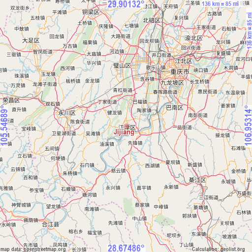
Jijiang GPS coordinates[2]
29° 17' 23.748" North, 106° 15' 0.036" East
| Map corner | latitude | longitude |
|---|---|---|
| Upper-left | 29.90132°, | 105.54689° |
| Center: | 29.28993°, | 106.25001° |
| Lower-right: | 28.67486°, | 106.95314° |
| Map W x H: | 136.4×136.4 km | = 84.8×84.8mi |
| max Lat: | 53.31946° ⇑62.1% North |
| Jijiang: | 29.28993° |
| min Lat: | ⇓37.9% South 18.22056° |
| min Long | Jijiang | max Long |
| 75.07348° | 106.25001° | 134.28917° |
| W 14%⇐ | ⇒86% E |
Elevation
Elevation of Jijiang is 213 m = 699 ft, and this is 271.8 m = 892 ft below average elevation for this country.
| Max E: |
5622 m = 18445 ft | 44.3% |
| Avg. | 484.8 m = 1591 ft | |
| Jijiang | 213 m = 699 ft | |
Min E: |
-3 m = -10 ft | 55.7% |
See also: Jijiang elevation on elevation.city.
Geographical zone
Jijiang is located in North temperate zone (between Tropic of Cancer and the Arctic Circle). Distance of this Northern Tropic circle is 650.8 km =404.4 mi to South.| Distance of | km | miles | from Jijiang |
|---|---|---|---|
| North Pole | 6750.3 | 4194.4 | to North |
| Arctic Circle | 4144.4 | 2575.2 | to North |
| Tropic Cancer | 650.8 | 404.4 | to South |
| Equator | 3256.7 | 2023.6 | to South |


Nearby cities:
15 places around Jijiang: (largest is in red/bold)
• Degan
2.2 km =1.4 mi,  234°
234°
• Dingjia
16.9 km =10.5 mi,  321°
321°
• Guangpu
11.4 km =7.1 mi,  296°
296°
• Jianlong
9.9 km =6.2 mi, 320°
• Longhua
9.8 km =6.1 mi,  205°
205°
• Luohuang
19 km =11.8 mi,  70°
70°
• Qinggang
19.8 km =12.3 mi,  356°
356°
• Sanhe
15.9 km =9.9 mi,  294°
294°
• Shiban
18 km =11.2 mi,  33°
33°
• Shuangfu
13.9 km =8.6 mi,  8°
8°
• Taojia
11.6 km =7.2 mi,  36°
36°
• Wutan
18.5 km =11.5 mi,  258°
258°
• Xianfeng
10.1 km =6.3 mi,  151°
151°
• Xipeng
6.9 km =4.3 mi,  86°
86°
• Youxi
13.6 km =8.5 mi, 228°
Sources, notices
• [Note1] Compared only with cities in China existing in our database
• [Src1] Map data: © OpenStreetMap contributors (CC-BY-SA)
• [Src2] Other city data from geonames.org with taken over terms of usage.
• [Src3] Geographical zone / Annual Mean Temperature by Robert A. Rohde @ Wikipedia
