Linquan geodata
Linquan (Shanxi) is a seat of a third-order administrative division; located in China in Asia/Shanghai (GMT+8) time zone. In our database, there are 1268 cities with bigger population. Compared to other cities in China, 80.9% of cities are located further ↓South; 66.9% of cities are located further →East and 85.8% of cities have lower elevation than Linquan. Note1


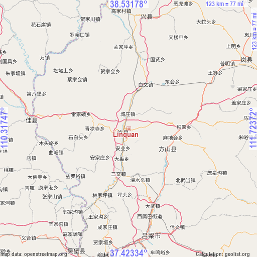
Linquan GPS coordinates[2]
37° 58' 46.74" North, 111° 1' 14.124" East
| Map corner | latitude | longitude |
|---|---|---|
| Upper-left | 38.53178°, | 110.31747° |
| Center: | 37.97965°, | 111.02059° |
| Lower-right: | 37.42334°, | 111.72372° |
| Map W x H: | 123.2×123.2 km | = 76.6×76.6mi |
| max Lat: | 53.31946° ⇑19.1% North |
| Linquan: | 37.97965° |
| min Lat: | ⇓80.9% South 18.22056° |
| min Long | Linquan | max Long |
| 75.07348° | 111.02059° | 134.28917° |
| W 33.1%⇐ | ⇒66.9% E |
Elevation
Elevation of Linquan is 1036 m = 3399 ft, and this is 551.2 m = 1808 ft above average elevation for this country.
| Max E: |
5622 m = 18445 ft | 14.2% |
| Linquan | 1036 m 3399 ft | |
| Avg. | 484.8 m = 1591 ft | |
Min E: |
-3 m = -10 ft | 85.8% |
See also: China elevation on elevation.city.
Geographical zone
Linquan is located in North temperate zone (between Tropic of Cancer and the Arctic Circle). Distance of this Northern Tropic circle is 1617 km =1004.8 mi to South.| Distance of | km | miles | from Linquan |
|---|---|---|---|
| North Pole | 5784.1 | 3594.1 | to North |
| Arctic Circle | 3178.2 | 1974.8 | to North |
| Tropic Cancer | 1617 | 1004.8 | to South |
| Equator | 4222.9 | 2624 | to South |


Nearby cities:
15 places around Linquan: (largest is in red/bold)
• Dongcun
69.2 km =43 mi,  59°
59°
• Dongqu
103.6 km =64.4 mi,  93°
93°
• Echeng
94 km =58.4 mi, 62°
• Fengcheng
107.1 km =66.5 mi,  124°
124°
• Gedong
22.7 km =14.1 mi, 115°
• Lanyi
96.5 km =60 mi,  31°
31°
• Lingquan
110.1 km =68.4 mi,  188°
188°
• Lishi
52.6 km =32.7 mi,  169°
169°
• Liulin
59.4 km =36.9 mi, 190°
• Loufan
70 km =43.5 mi,  79°
79°
• Ningxiang
73 km =45.4 mi, 167°
• Shijiazhuang
109.2 km =67.9 mi,  52°
52°
• Tianning
111.1 km =69 mi, 115°
• Weifen
57.1 km =35.5 mi,  12°
12°
• Xinbu
106.1 km =65.9 mi, 49°
Sources, notices
• [Note1] Compared only with cities in China existing in our database
• [Src1] Map data: © OpenStreetMap contributors (CC-BY-SA)
• [Src2] Other city data from geonames.org with taken over terms of usage.
• [Src3] Geographical zone / Annual Mean Temperature by Robert A. Rohde @ Wikipedia
