Ningxiang geodata
Ningxiang (Shanxi) is a seat of a third-order administrative division; located in China in Asia/Shanghai (GMT+8) time zone. In our database, there are 1268 cities with bigger population. Compared to other cities in China, 79.9% of cities are located further ↓South; 66.2% of cities are located further →East and 88.5% of cities have lower elevation than Ningxiang. Note1


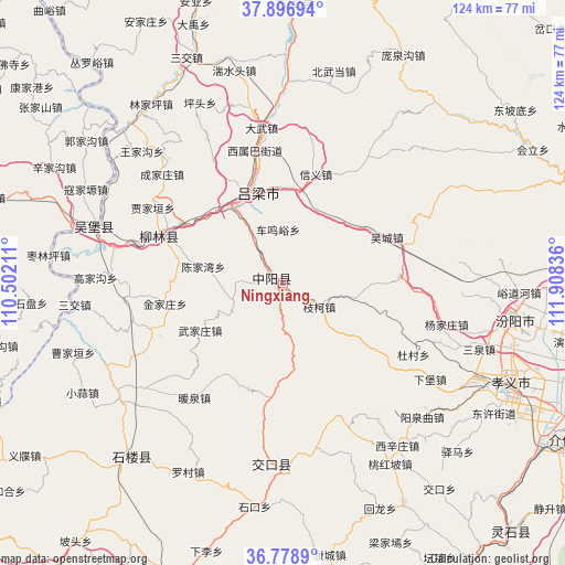
Ningxiang GPS coordinates[2]
37° 20' 24" North, 111° 12' 18.828" East
| Map corner | latitude | longitude |
|---|---|---|
| Upper-left | 37.89694°, | 110.50211° |
| Center: | 37.34°, | 111.20523° |
| Lower-right: | 36.7789°, | 111.90836° |
| Map W x H: | 124.3×124.3 km | = 77.2×77.2mi |
| max Lat: | 53.31946° ⇑20.1% North |
| Ningxiang: | 37.34° |
| min Lat: | ⇓79.9% South 18.22056° |
| min Long | Ningxiang | max Long |
| 75.07348° | 111.20523° | 134.28917° |
| W 33.8%⇐ | ⇒66.2% E |
Elevation
Elevation of Ningxiang is 1231 m = 4039 ft, and this is 746.2 m = 2448 ft above average elevation for this country.
| Max E: |
5622 m = 18445 ft | 11.5% |
| Ningxiang | 1231 m 4039 ft | |
| Avg. | 484.8 m = 1591 ft | |
Min E: |
-3 m = -10 ft | 88.5% |
See also: China elevation on elevation.city.
Geographical zone
Ningxiang is located in North temperate zone (between Tropic of Cancer and the Arctic Circle). Distance of this Northern Tropic circle is 1545.9 km =960.6 mi to South.| Distance of | km | miles | from Ningxiang |
|---|---|---|---|
| North Pole | 5855.2 | 3638.3 | to North |
| Arctic Circle | 3249.4 | 2019.1 | to North |
| Tropic Cancer | 1545.9 | 960.6 | to South |
| Equator | 4151.8 | 2579.8 | to South |


Nearby cities:
15 places around Ningxiang: (largest is in red/bold)
• Cuifeng
75.1 km =46.7 mi,  137°
137°
• Fengcheng
73 km =45.4 mi,  81°
81°
• Gedong
61.7 km =38.3 mi,  4°
4°
• Gutao
87.4 km =54.3 mi,  100°
100°
• Jiexiu
71.8 km =44.6 mi,  119°
119°
• Lingquan
49.6 km =30.8 mi,  220°
220°
• Linquan
73 km =45.4 mi,  347°
347°
• Lishi
20.5 km =12.7 mi,  342°
342°
• Liulin
29.6 km =18.4 mi,  295°
295°
• Longquan
75 km =46.6 mi,  197°
197°
• Shuitou
40.8 km =25.4 mi,  179°
179°
• Tianning
87.4 km =54.3 mi,  74°
74°
• Yong’an
82.4 km =51.2 mi,  157°
157°
• Zhaoyu
98.3 km =61.1 mi,  89°
89°
• Zhihe
80 km =49.7 mi, 218°
Sources, notices
• [Note1] Compared only with cities in China existing in our database
• [Src1] Map data: © OpenStreetMap contributors (CC-BY-SA)
• [Src2] Other city data from geonames.org with taken over terms of usage.
• [Src3] Geographical zone / Annual Mean Temperature by Robert A. Rohde @ Wikipedia
