Gedong geodata
Gedong (Shanxi) is a seat of a third-order administrative division; located in China in Asia/Shanghai (GMT+8) time zone. In our database, there are 1268 cities with bigger population. Compared to other cities in China, 80.8% of cities are located further ↓South; 66.1% of cities are located further →East and 89% of cities have lower elevation than Gedong. Note1


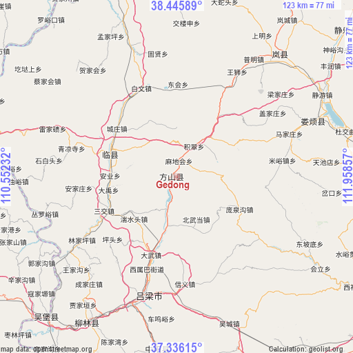
Gedong GPS coordinates[2]
37° 53' 35.196" North, 111° 15' 19.584" East
| Map corner | latitude | longitude |
|---|---|---|
| Upper-left | 38.44589°, | 110.55232° |
| Center: | 37.89311°, | 111.25544° |
| Lower-right: | 37.33615°, | 111.95857° |
| Map W x H: | 123.4×123.4 km | = 76.7×76.7mi |
| max Lat: | 53.31946° ⇑19.2% North |
| Gedong: | 37.89311° |
| min Lat: | ⇓80.8% South 18.22056° |
| min Long | Gedong | max Long |
| 75.07348° | 111.25544° | 134.28917° |
| W 33.9%⇐ | ⇒66.1% E |
Elevation
Elevation of Gedong is 1268 m = 4160 ft, and this is 783.2 m = 2570 ft above average elevation for this country.
| Max E: |
5622 m = 18445 ft | 11% |
| Gedong | 1268 m 4160 ft | |
| Avg. | 484.8 m = 1591 ft | |
Min E: |
-3 m = -10 ft | 89% |
See also: China elevation on elevation.city.
Geographical zone
Gedong is located in North temperate zone (between Tropic of Cancer and the Arctic Circle). Distance of this Northern Tropic circle is 1607.4 km =998.8 mi to South.| Distance of | km | miles | from Gedong |
|---|---|---|---|
| North Pole | 5793.7 | 3600 | to North |
| Arctic Circle | 3187.9 | 1980.9 | to North |
| Tropic Cancer | 1607.4 | 998.8 | to South |
| Equator | 4213.3 | 2618 | to South |


Nearby cities:
15 places around Gedong: (largest is in red/bold)
• Dongcun
59.4 km =36.9 mi,  41°
41°
• Dongqu
82.9 km =51.5 mi,  87°
87°
• Echeng
82.4 km =51.2 mi,  49°
49°
• Fengcheng
84.8 km =52.7 mi,  127°
127°
• Lanyi
96.7 km =60.1 mi,  18°
18°
• Linquan
22.7 km =14.1 mi,  295°
295°
• Lishi
43.3 km =26.9 mi,  194°
194°
• Liulin
58 km =36 mi,  212°
212°
• Loufan
53.2 km =33.1 mi,  65°
65°
• Ningxiang
61.7 km =38.3 mi,  184°
184°
• Qingyuan
99 km =61.5 mi,  108°
108°
• Shijiazhuang
100.8 km =62.6 mi, 41°
• Tianning
88.4 km =54.9 mi,  115°
115°
• Weifen
65.8 km =40.9 mi,  353°
353°
• Xinbu
99.1 km =61.6 mi, 37°
Sources, notices
• [Note1] Compared only with cities in China existing in our database
• [Src1] Map data: © OpenStreetMap contributors (CC-BY-SA)
• [Src2] Other city data from geonames.org with taken over terms of usage.
• [Src3] Geographical zone / Annual Mean Temperature by Robert A. Rohde @ Wikipedia
