Lintingkou geodata
Lintingkou (Tianjin) is a populated place; located in China in Asia/Shanghai (GMT+8) time zone. With population of 3,521 people, there are 922 cities with bigger population in this country. Compared to other cities in China, 85.1% of cities are located further ↓South; 68.7% of cities are located further ←West and 99.9% of cities have higher elevation than Lintingkou. Note1


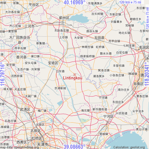
Lintingkou GPS coordinates[2]
39° 37' 49.008" North, 117° 30' 1.008" East
| Map corner | latitude | longitude |
|---|---|---|
| Upper-left | 40.16969°, | 116.79716° |
| Center: | 39.63028°, | 117.50028° |
| Lower-right: | 39.08663°, | 118.20341° |
| Map W x H: | 120.4×120.4 km | = 74.8×74.8mi |
| max Lat: | 53.31946° ⇑14.9% North |
| Lintingkou: | 39.63028° |
| min Lat: | ⇓85.1% South 18.22056° |
| min Long | Lintingkou | max Long |
| 75.07348° | 117.50028° | 134.28917° |
| W 68.7%⇐ | ⇒31.3% E |
Elevation
Elevation of Lintingkou is -1 m = -3 ft, and this is 485.8 m = 1594 ft below average elevation for this country.
| Max E: |
5622 m = 18445 ft | 99.9% |
| Avg. | 484.8 m = 1591 ft | |
| Lintingkou | -1 m = -3 ft | |
Min E: |
-3 m = -10 ft | 0.1% |
See also: China elevation on elevation.city.
Geographical zone
Lintingkou is located in North temperate zone (between Tropic of Cancer and the Arctic Circle). Distance of this Northern Tropic circle is 1800.6 km =1118.8 mi to South.| Distance of | km | miles | from Lintingkou |
|---|---|---|---|
| North Pole | 5600.6 | 3480.1 | to North |
| Arctic Circle | 2994.7 | 1860.8 | to North |
| Tropic Cancer | 1800.6 | 1118.8 | to South |
| Equator | 4406.5 | 2738.1 | to South |


Nearby cities:
15 places around Lintingkou: (largest is in red/bold)
• Bamencheng
10.7 km =6.6 mi,  122°
122°
• Beilizigu
15.7 km =9.8 mi,  191°
191°
• Beitan
15 km =9.3 mi,  341°
341°
• Dazhongzhuang
7.8 km =4.8 mi,  44°
44°
• Fangjiazhuang
13 km =8.1 mi,  328°
328°
• Heilangkou
8.7 km =5.4 mi,  257°
257°
• Huangzhuang
16.6 km =10.3 mi,  176°
176°
• Huogezhuang
17 km =10.6 mi,  318°
318°
• Shiqiao
18.7 km =11.6 mi,  291°
291°
• Wangbuzhuang
8.1 km =5 mi,  310°
310°
• Xiacang
18.8 km =11.7 mi, 337°
• Xin’anzhen
13.8 km =8.6 mi,  11°
11°
• Yuguzhuang
12.2 km =7.6 mi,  275°
275°
• Zhongdeng
13.4 km =8.3 mi,  250°
250°
• Zhuangtou
18.1 km =11.2 mi, 279°
Sources, notices
• [Note1] Compared only with cities in China existing in our database
• [Src1] Map data: © OpenStreetMap contributors (CC-BY-SA)
• [Src2] Other city data from geonames.org with taken over terms of usage.
• [Src3] Geographical zone / Annual Mean Temperature by Robert A. Rohde @ Wikipedia
