Heping geodata
Heping (Hunan) is a seat of a fourth-order administrative division; located in China in Asia/Shanghai (GMT+8) time zone. In our database, there are 1268 cities with bigger population. Compared to other cities in China, 66% of cities are located further ↑North; 72.7% of cities are located further →East and 64.6% of cities have lower elevation than Heping. Note1


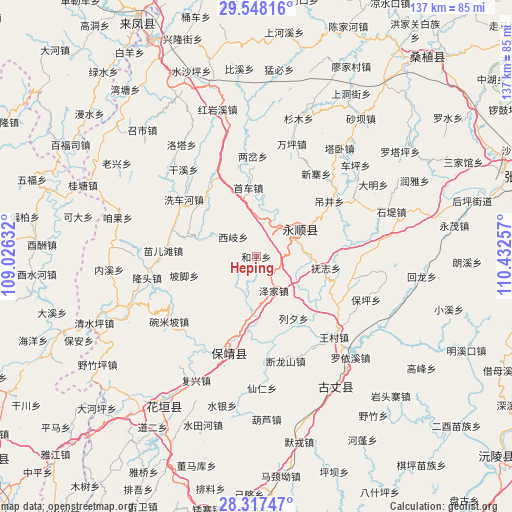
Heping GPS coordinates[2]
28° 56' 4.704" North, 109° 43' 45.984" East
| Map corner | latitude | longitude |
|---|---|---|
| Upper-left | 29.54816°, | 109.02632° |
| Center: | 28.93464°, | 109.72944° |
| Lower-right: | 28.31747°, | 110.43257° |
| Map W x H: | 136.8×136.8 km | = 85×85mi |
| max Lat: | 53.31946° ⇑66% North |
| Heping: | 28.93464° |
| min Lat: | ⇓34% South 18.22056° |
| min Long | Heping | max Long |
| 75.07348° | 109.72944° | 134.28917° |
| W 27.3%⇐ | ⇒72.7% E |
Elevation
Elevation of Heping is 319 m = 1047 ft, and this is 165.8 m = 544 ft below average elevation for this country.
| Max E: |
5622 m = 18445 ft | 35.4% |
| Avg. | 484.8 m = 1591 ft | |
| Heping | 319 m = 1047 ft | |
Min E: |
-3 m = -10 ft | 64.6% |
See also: China elevation on elevation.city.
Geographical zone
Heping is located in North temperate zone (between Tropic of Cancer and the Arctic Circle). Distance of this Northern Tropic circle is 611.3 km =379.8 mi to South.| Distance of | km | miles | from Heping |
|---|---|---|---|
| North Pole | 6789.8 | 4219 | to North |
| Arctic Circle | 4183.9 | 2599.8 | to North |
| Tropic Cancer | 611.3 | 379.8 | to South |
| Equator | 3217.2 | 1999.1 | to South |


Nearby cities:
15 places around Heping: (largest is in red/bold)
• Baiyang
14.2 km =8.8 mi,  178°
178°
• Daba
6.9 km =4.3 mi,  91°
91°
• Dianfang
16.3 km =10.1 mi,  286°
286°
• Duishan
7.4 km =4.6 mi,  249°
249°
• Fuzhiping
19.4 km =12.1 mi,  102°
102°
• Liandonggang
16.9 km =10.5 mi,  61°
61°
• Liexi
19.3 km =12 mi,  148°
148°
• Lingxi
13.7 km =8.5 mi, 55°
• Pojiao
19.9 km =12.4 mi,  255°
255°
• Purong
13.9 km =8.6 mi,  232°
232°
• Shaoha
10.5 km =6.5 mi,  21°
21°
• Tasha
20.9 km =13 mi,  310°
310°
• Xiqi
8.1 km =5 mi, 310°
• Yanbanpu
20.1 km =12.5 mi,  29°
29°
• Zejia
10.3 km =6.4 mi, 152°
Sources, notices
• [Note1] Compared only with cities in China existing in our database
• [Src1] Map data: © OpenStreetMap contributors (CC-BY-SA)
• [Src2] Other city data from geonames.org with taken over terms of usage.
• [Src3] Geographical zone / Annual Mean Temperature by Robert A. Rohde @ Wikipedia
