Lingtou geodata
Lingtou (Fujian) is a seat of a fourth-order administrative division; located in China in Asia/Shanghai (GMT+8) time zone. With population of 380 people, there are 1266 cities with bigger population in this country. Compared to other cities in China, 81.6% of cities are located further ↑North; 77.4% of cities are located further ←West and 71.2% of cities have lower elevation than Lingtou. Note1


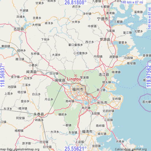
Lingtou GPS coordinates[2]
26° 11' 19.86" North, 119° 16' 20.964" East
| Map corner | latitude | longitude |
|---|---|---|
| Upper-left | 26.81808°, | 118.56937° |
| Center: | 26.18885°, | 119.27249° |
| Lower-right: | 25.55621°, | 119.97562° |
| Map W x H: | 140.3×140.3 km | = 87.2×87.2mi |
| max Lat: | 53.31946° ⇑81.6% North |
| Lingtou: | 26.18885° |
| min Lat: | ⇓18.4% South 18.22056° |
| min Long | Lingtou | max Long |
| 75.07348° | 119.27249° | 134.28917° |
| W 77.4%⇐ | ⇒22.6% E |
Elevation
Elevation of Lingtou is 434 m = 1424 ft, and this is 50.8 m = 167 ft below average elevation for this country.
| Max E: |
5622 m = 18445 ft | 28.8% |
| Avg. | 484.8 m = 1591 ft | |
| Lingtou | 434 m = 1424 ft | |
Min E: |
-3 m = -10 ft | 71.2% |
See also: China elevation on elevation.city.
Geographical zone
Lingtou is located in North temperate zone (between Tropic of Cancer and the Arctic Circle). Distance of this Northern Tropic circle is 306 km =190.1 mi to South.| Distance of | km | miles | from Lingtou |
|---|---|---|---|
| North Pole | 7095.1 | 4408.7 | to North |
| Arctic Circle | 4489.2 | 2789.5 | to North |
| Tropic Cancer | 306 | 190.1 | to South |
| Equator | 2911.9 | 1809.4 | to South |


Nearby cities:
15 places around Lingtou: (largest is in red/bold)
• Chayuan
9.3 km =5.8 mi,  152°
152°
• Dongjie
11.4 km =7.1 mi,  168°
168°
• Gudong
10.9 km =6.8 mi, 167°
• Gulou
11.7 km =7.3 mi, 167°
• Guxi
11.1 km =6.9 mi, 173°
• Huada
9.9 km =6.2 mi, 171°
• Huai’an
11.2 km =7 mi,  206°
206°
• Huanxi
8.3 km =5.2 mi,  101°
101°
• Jingxi
11.7 km =7.3 mi,  235°
235°
• Nanjie
11.5 km =7.1 mi, 171°
• Shoushan
7.1 km =4.4 mi,  329°
329°
• Wenquan
10.4 km =6.5 mi,  162°
162°
• Wufeng
9.3 km =5.8 mi,  176°
176°
• Xindian
7.9 km =4.9 mi, 158°
• Yuefeng
11.7 km =7.3 mi, 156°
Sources, notices
• [Note1] Compared only with cities in China existing in our database
• [Src1] Map data: © OpenStreetMap contributors (CC-BY-SA)
• [Src2] Other city data from geonames.org with taken over terms of usage.
• [Src3] Geographical zone / Annual Mean Temperature by Robert A. Rohde @ Wikipedia
