Jingxi geodata
Jingxi (Fujian) is a seat of a fourth-order administrative division; located in China in Asia/Shanghai (GMT+8) time zone. In our database, there are 1268 cities with bigger population. Compared to other cities in China, 81.8% of cities are located further ↑North; 76.9% of cities are located further ←West and 85.5% of cities have higher elevation than Jingxi. Note1


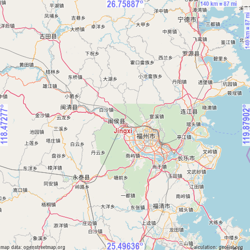
Jingxi GPS coordinates[2]
26° 7' 45.552" North, 119° 10' 33.204" East
| Map corner | latitude | longitude |
|---|---|---|
| Upper-left | 26.75887°, | 118.47277° |
| Center: | 26.12932°, | 119.17589° |
| Lower-right: | 25.49636°, | 119.87902° |
| Map W x H: | 140.4×140.4 km | = 87.2×87.2mi |
| max Lat: | 53.31946° ⇑81.8% North |
| Jingxi: | 26.12932° |
| min Lat: | ⇓18.2% South 18.22056° |
| min Long | Jingxi | max Long |
| 75.07348° | 119.17589° | 134.28917° |
| W 76.9%⇐ | ⇒23.1% E |
Elevation
Elevation of Jingxi is 15 m = 49 ft, and this is 469.8 m = 1541 ft below average elevation for this country.
| Max E: |
5622 m = 18445 ft | 85.5% |
| Avg. | 484.8 m = 1591 ft | |
| Jingxi | 15 m = 49 ft | |
Min E: |
-3 m = -10 ft | 14.5% |
See also: China elevation on elevation.city.
Geographical zone
Jingxi is located in North temperate zone (between Tropic of Cancer and the Arctic Circle). Distance of this Northern Tropic circle is 299.4 km =186 mi to South.| Distance of | km | miles | from Jingxi |
|---|---|---|---|
| North Pole | 7101.8 | 4412.9 | to North |
| Arctic Circle | 4495.9 | 2793.6 | to North |
| Tropic Cancer | 299.4 | 186 | to South |
| Equator | 2905.3 | 1805.3 | to South |


Nearby cities:
15 places around Jingxi: (largest is in red/bold)
• Dongjie
12.7 km =7.9 mi,  111°
111°
• Gudong
12.7 km =7.9 mi, 108°
• Guxi
11.7 km =7.3 mi, 112°
• Hongshan
11 km =6.8 mi,  120°
120°
• Hongtang
8.5 km =5.3 mi,  139°
139°
• Huada
11.6 km =7.2 mi, 105°
• Huai’an
5.7 km =3.5 mi,  126°
126°
• Jianxin
8.5 km =5.3 mi, 140°
• Lingtou
11.7 km =7.3 mi,  55°
55°
• Nanjie
12.3 km =7.6 mi, 112°
• Rong’an
5.5 km =3.4 mi,  264°
264°
• Shangjie
4.8 km =3 mi,  169°
169°
• Wufeng
10.6 km =6.6 mi,  104°
104°
• Xindian
12.6 km =7.8 mi,  93°
93°
• Zhuqi
7.7 km =4.8 mi,  286°
286°
Sources, notices
• [Note1] Compared only with cities in China existing in our database
• [Src1] Map data: © OpenStreetMap contributors (CC-BY-SA)
• [Src2] Other city data from geonames.org with taken over terms of usage.
• [Src3] Geographical zone / Annual Mean Temperature by Robert A. Rohde @ Wikipedia
