Lingkou geodata
Lingkou (Jiangsu) is a seat of a fourth-order administrative division; located in China in Asia/Shanghai (GMT+8) time zone. In our database, there are 1268 cities with bigger population. Compared to other cities in China, 60.9% of cities are located further ↓South; 79.7% of cities are located further ←West and 92.7% of cities have higher elevation than Lingkou. Note1


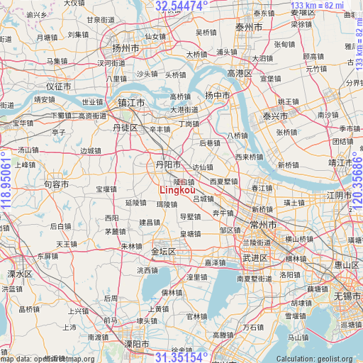
Lingkou GPS coordinates[2]
31° 57' 0.288" North, 119° 39' 13.428" East
| Map corner | latitude | longitude |
|---|---|---|
| Upper-left | 32.54474°, | 118.95061° |
| Center: | 31.95008°, | 119.65373° |
| Lower-right: | 31.35154°, | 120.35686° |
| Map W x H: | 132.7×132.7 km | = 82.5×82.5mi |
| max Lat: | 53.31946° ⇑39.1% North |
| Lingkou: | 31.95008° |
| min Lat: | ⇓60.9% South 18.22056° |
| min Long | Lingkou | max Long |
| 75.07348° | 119.65373° | 134.28917° |
| W 79.7%⇐ | ⇒20.3% E |
Elevation
Elevation of Lingkou is 8 m = 26 ft, and this is 476.8 m = 1564 ft below average elevation for this country.
| Max E: |
5622 m = 18445 ft | 92.7% |
| Avg. | 484.8 m = 1591 ft | |
| Lingkou | 8 m = 26 ft | |
Min E: |
-3 m = -10 ft | 7.3% |
See also: China elevation on elevation.city.
Geographical zone
Lingkou is located in North temperate zone (between Tropic of Cancer and the Arctic Circle). Distance of this Northern Tropic circle is 946.6 km =588.2 mi to South.| Distance of | km | miles | from Lingkou |
|---|---|---|---|
| North Pole | 6454.5 | 4010.6 | to North |
| Arctic Circle | 3848.7 | 2391.5 | to North |
| Tropic Cancer | 946.6 | 588.2 | to South |
| Equator | 3552.5 | 2207.4 | to South |


Nearby cities:
15 places around Lingkou: (largest is in red/bold)
• Benniu
17.7 km =11 mi,  123°
123°
• Dashu
12.8 km =8 mi,  165°
165°
• Erling
9.6 km =6 mi,  215°
215°
• Fangxian
9.5 km =5.9 mi,  53°
53°
• Houxiang
19.8 km =12.3 mi,  30°
30°
• Huangtang
18.8 km =11.7 mi, 169°
• Luoxi
15 km =9.3 mi,  109°
109°
• Lücheng
9.6 km =6 mi,  126°
126°
• Menghe
19.9 km =12.4 mi,  68°
68°
• Picheng
19.3 km =12 mi,  14°
14°
• Situ
15.7 km =9.8 mi,  292°
292°
• Xinqiao
19.9 km =12.4 mi, 46°
• Xixiashu
15.7 km =9.8 mi,  89°
89°
• Yanling
18.4 km =11.4 mi,  245°
245°
• Yunyang
9.8 km =6.1 mi,  301°
301°
Sources, notices
• [Note1] Compared only with cities in China existing in our database
• [Src1] Map data: © OpenStreetMap contributors (CC-BY-SA)
• [Src2] Other city data from geonames.org with taken over terms of usage.
• [Src3] Geographical zone / Annual Mean Temperature by Robert A. Rohde @ Wikipedia
