Huangtang geodata
Huangtang (Jiangsu) is a seat of a fourth-order administrative division; located in China in Asia/Shanghai (GMT+8) time zone. In our database, there are 1268 cities with bigger population. Compared to other cities in China, 60% of cities are located further ↓South; 79.9% of cities are located further ←West and 94.3% of cities have higher elevation than Huangtang. Note1


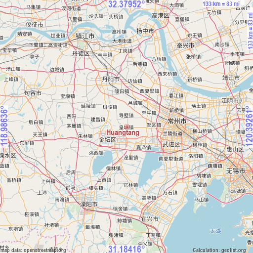
Huangtang GPS coordinates[2]
31° 47' 1.572" North, 119° 41' 22.128" East
| Map corner | latitude | longitude |
|---|---|---|
| Upper-left | 32.37952°, | 118.98636° |
| Center: | 31.78377°, | 119.68948° |
| Lower-right: | 31.18416°, | 120.39261° |
| Map W x H: | 132.9×132.9 km | = 82.6×82.6mi |
| max Lat: | 53.31946° ⇑40% North |
| Huangtang: | 31.78377° |
| min Lat: | ⇓60% South 18.22056° |
| min Long | Huangtang | max Long |
| 75.07348° | 119.68948° | 134.28917° |
| W 79.9%⇐ | ⇒20.1% E |
Elevation
Elevation of Huangtang is 7 m = 23 ft, and this is 477.8 m = 1568 ft below average elevation for this country.
| Max E: |
5622 m = 18445 ft | 94.3% |
| Avg. | 484.8 m = 1591 ft | |
| Huangtang | 7 m = 23 ft | |
Min E: |
-3 m = -10 ft | 5.7% |
See also: China elevation on elevation.city.
Geographical zone
Huangtang is located in North temperate zone (between Tropic of Cancer and the Arctic Circle). Distance of this Northern Tropic circle is 928.1 km =576.7 mi to South.| Distance of | km | miles | from Huangtang |
|---|---|---|---|
| North Pole | 6473 | 4022.1 | to North |
| Arctic Circle | 3867.2 | 2403 | to North |
| Tropic Cancer | 928.1 | 576.7 | to South |
| Equator | 3534 | 2195.9 | to South |


Nearby cities:
15 places around Huangtang: (largest is in red/bold)
• Beigang
17.9 km =11.1 mi,  85°
85°
• Benniu
14.3 km =8.9 mi,  52°
52°
• Dashu
6 km =3.7 mi,  357°
357°
• Erling
13.9 km =8.6 mi,  320°
320°
• Huangli
16.6 km =10.3 mi,  172°
172°
• Jianchang
18.9 km =11.7 mi,  282°
282°
• Jiaze
14.1 km =8.8 mi,  139°
139°
• Jincheng
11.8 km =7.3 mi,  248°
248°
• Lingkou
18.8 km =11.7 mi,  349°
349°
• Luoxi
17.2 km =10.7 mi,  38°
38°
• Lücheng
13.5 km =8.4 mi,  18°
18°
• Xilin
18.7 km =11.6 mi,  95°
95°
• Yaotang
7.4 km =4.6 mi,  189°
189°
• Yong’an
17.1 km =10.6 mi,  197°
197°
• Zouqu
14.3 km =8.9 mi,  84°
84°
Sources, notices
• [Note1] Compared only with cities in China existing in our database
• [Src1] Map data: © OpenStreetMap contributors (CC-BY-SA)
• [Src2] Other city data from geonames.org with taken over terms of usage.
• [Src3] Geographical zone / Annual Mean Temperature by Robert A. Rohde @ Wikipedia
