Lili geodata
Lili (Jiangsu) is a seat of a fourth-order administrative division; located in China in Asia/Shanghai (GMT+8) time zone. In our database, there are 1268 cities with bigger population. Compared to other cities in China, 54.8% of cities are located further ↓South; 86.3% of cities are located further ←West and 92.7% of cities have higher elevation than Lili. Note1


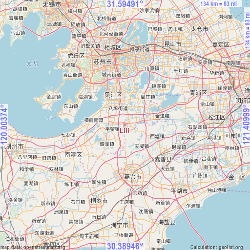
Lili GPS coordinates[2]
30° 59' 38.724" North, 120° 42' 24.696" East
| Map corner | latitude | longitude |
|---|---|---|
| Upper-left | 31.59491°, | 120.00374° |
| Center: | 30.99409°, | 120.70686° |
| Lower-right: | 30.38946°, | 121.40999° |
| Map W x H: | 134×134 km | = 83.3×83.3mi |
| max Lat: | 53.31946° ⇑45.2% North |
| Lili: | 30.99409° |
| min Lat: | ⇓54.8% South 18.22056° |
| min Long | Lili | max Long |
| 75.07348° | 120.70686° | 134.28917° |
| W 86.3%⇐ | ⇒13.7% E |
Elevation
Elevation of Lili is 8 m = 26 ft, and this is 476.8 m = 1564 ft below average elevation for this country.
| Max E: |
5622 m = 18445 ft | 92.7% |
| Avg. | 484.8 m = 1591 ft | |
| Lili | 8 m = 26 ft | |
Min E: |
-3 m = -10 ft | 7.3% |
See also: China elevation on elevation.city.
Geographical zone
Lili is located in North temperate zone (between Tropic of Cancer and the Arctic Circle). Distance of this Northern Tropic circle is 840.3 km =522.1 mi to South.| Distance of | km | miles | from Lili |
|---|---|---|---|
| North Pole | 6560.8 | 4076.7 | to North |
| Arctic Circle | 3955 | 2457.5 | to North |
| Tropic Cancer | 840.3 | 522.1 | to South |
| Equator | 3446.2 | 2141.4 | to South |


Nearby cities:
15 places around Lili: (largest is in red/bold)
• Fenhu
12.6 km =7.8 mi,  80°
80°
• Hengshan
16.5 km =10.3 mi,  279°
279°
• Hongxi
15.6 km =9.7 mi,  126°
126°
• Meiyan
11.7 km =7.3 mi,  261°
261°
• Pingwang
7 km =4.3 mi,  253°
253°
• Shengze
10.1 km =6.3 mi,  200°
200°
• Songlong
19.8 km =12.3 mi,  340°
340°
• Taozhuang
9.9 km =6.2 mi,  106°
106°
• Tianning
14.1 km =8.8 mi,  140°
140°
• Tongli
18.6 km =11.6 mi,  1°
1°
• Wangjiangjing
12.3 km =7.6 mi,  180°
180°
• Xitang
18 km =11.2 mi, 106°
• Yangmiao
18.8 km =11.7 mi,  145°
145°
• Youchegang
18.8 km =11.7 mi,  167°
167°
• Zhouzhuang
19 km =11.8 mi,  43°
43°
Sources, notices
• [Note1] Compared only with cities in China existing in our database
• [Src1] Map data: © OpenStreetMap contributors (CC-BY-SA)
• [Src2] Other city data from geonames.org with taken over terms of usage.
• [Src3] Geographical zone / Annual Mean Temperature by Robert A. Rohde @ Wikipedia
