Zhouzhuang geodata
Zhouzhuang (Jiangsu) is a seat of a fourth-order administrative division; located in China in Asia/Shanghai (GMT+8) time zone. With population of 22,000 people, there are 806 cities with bigger population in this country. Compared to other cities in China, 55.7% of cities are located further ↓South; 87% of cities are located further ←West and 95.9% of cities have higher elevation than Zhouzhuang. Note1


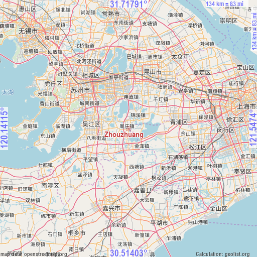
Zhouzhuang GPS coordinates[2]
31° 7' 4.368" North, 120° 50' 39.372" East
| Map corner | latitude | longitude |
|---|---|---|
| Upper-left | 31.71791°, | 120.14115° |
| Center: | 31.11788°, | 120.84427° |
| Lower-right: | 30.51403°, | 121.5474° |
| Map W x H: | 133.9×133.9 km | = 83.2×83.2mi |
| max Lat: | 53.31946° ⇑44.3% North |
| Zhouzhuang: | 31.11788° |
| min Lat: | ⇓55.7% South 18.22056° |
| min Long | Zhouzhuang | max Long |
| 75.07348° | 120.84427° | 134.28917° |
| W 87%⇐ | ⇒13% E |
Elevation
Elevation of Zhouzhuang is 6 m = 20 ft, and this is 478.8 m = 1571 ft below average elevation for this country.
| Max E: |
5622 m = 18445 ft | 95.9% |
| Avg. | 484.8 m = 1591 ft | |
| Zhouzhuang | 6 m = 20 ft | |
Min E: |
-3 m = -10 ft | 4.1% |
See also: China elevation on elevation.city.
Geographical zone
Zhouzhuang is located in North temperate zone (between Tropic of Cancer and the Arctic Circle). Distance of this Northern Tropic circle is 854.1 km =530.7 mi to South.| Distance of | km | miles | from Zhouzhuang |
|---|---|---|---|
| North Pole | 6547.1 | 4068.2 | to North |
| Arctic Circle | 3941.2 | 2448.9 | to North |
| Tropic Cancer | 854.1 | 530.7 | to South |
| Equator | 3460 | 2149.9 | to South |


Nearby cities:
15 places around Zhouzhuang: (largest is in red/bold)
• Dianshanhu
18.7 km =11.6 mi,  66°
66°
• Dingzha
16.7 km =10.4 mi,  145°
145°
• Fenhu
11.6 km =7.2 mi,  183°
183°
• Jinxi
8.3 km =5.2 mi,  34°
34°
• Jinze
11.2 km =7 mi,  143°
143°
• Lili
19 km =11.8 mi,  223°
223°
• Luzhi
17.8 km =11.1 mi,  7°
7°
• Shengpu
21 km =13 mi,  352°
352°
• Songling
14.7 km =9.1 mi,  304°
304°
• Songlong
20.2 km =12.6 mi,  284°
284°
• Taozhuang
16.9 km =10.5 mi,  192°
192°
• Tongli
13.5 km =8.4 mi,  290°
290°
• Xitang
19.4 km =12.1 mi,  167°
167°
• Zhangpu
21.2 km =13.2 mi, 27°
• Zhujiajiao
20.3 km =12.6 mi,  93°
93°
Sources, notices
• [Note1] Compared only with cities in China existing in our database
• [Src1] Map data: © OpenStreetMap contributors (CC-BY-SA)
• [Src2] Other city data from geonames.org with taken over terms of usage.
• [Src3] Geographical zone / Annual Mean Temperature by Robert A. Rohde @ Wikipedia
