Jingdezhen geodata
Jingdezhen (Jiangxi) is a seat of a second-order administrative division; located in China in Asia/Shanghai (GMT+8) time zone. With population of 310,565 people, there are 177 cities with bigger population in this country. Compared to other cities in China, 62% of cities are located further ↑North; 67.2% of cities are located further ←West and 71% of cities have higher elevation than Jingdezhen. Note1


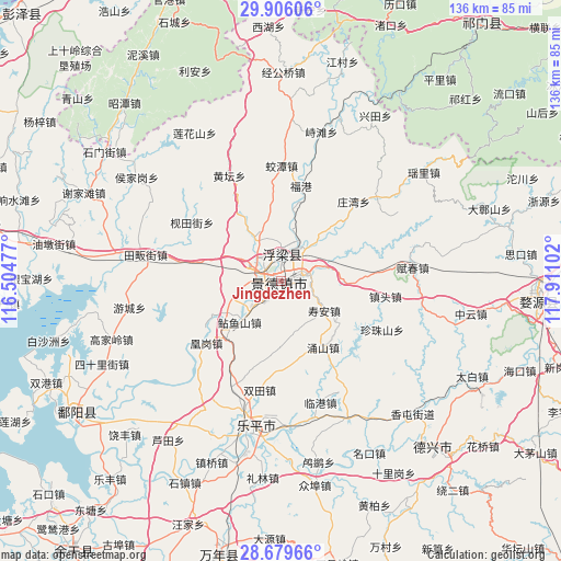
Jingdezhen GPS coordinates[2]
29° 17' 40.92" North, 117° 12' 28.404" East
| Map corner | latitude | longitude |
|---|---|---|
| Upper-left | 29.90606°, | 116.50477° |
| Center: | 29.2947°, | 117.20789° |
| Lower-right: | 28.67966°, | 117.91102° |
| Map W x H: | 136.4×136.4 km | = 84.8×84.8mi |
| max Lat: | 53.31946° ⇑62% North |
| Jingdezhen: | 29.2947° |
| min Lat: | ⇓38% South 18.22056° |
| min Long | Jingdezhen | max Long |
| 75.07348° | 117.20789° | 134.28917° |
| W 67.2%⇐ | ⇒32.8% E |
Elevation
Elevation of Jingdezhen is 48 m = 157 ft, and this is 436.8 m = 1433 ft below average elevation for this country.
| Max E: |
5622 m = 18445 ft | 71% |
| Avg. | 484.8 m = 1591 ft | |
| Jingdezhen | 48 m = 157 ft | |
Min E: |
-3 m = -10 ft | 29% |
See also: Jingdezhen elevation on elevation.city.
Geographical zone
Jingdezhen is located in North temperate zone (between Tropic of Cancer and the Arctic Circle). Distance of this Northern Tropic circle is 651.3 km =404.7 mi to South.| Distance of | km | miles | from Jingdezhen |
|---|---|---|---|
| North Pole | 6749.8 | 4194.1 | to North |
| Arctic Circle | 4143.9 | 2574.9 | to North |
| Tropic Cancer | 651.3 | 404.7 | to South |
| Equator | 3257.3 | 2024 | to South |


Nearby cities:
15 places around Jingdezhen: (largest is in red/bold)
• Fuliang
9.8 km =6.1 mi,  22°
22°
• Hetang
14.7 km =9.1 mi,  207°
207°
• Hongyuan
6.3 km =3.9 mi,  298°
298°
• Huanggang
25.1 km =15.6 mi,  232°
232°
• Jiantianjie
25.8 km =16 mi, 303°
• Jingcheng
1.5 km =0.9 mi,  139°
139°
• Jinpanling
21.1 km =13.1 mi,  282°
282°
• Liyang
18.5 km =11.5 mi,  243°
243°
• Lümeng
4.5 km =2.8 mi, 231°
• Nianyushan
14.1 km =8.8 mi, 225°
• Sanlong
11.8 km =7.3 mi,  328°
328°
• Wanggang
14.7 km =9.1 mi,  44°
44°
• Xianghu
11 km =6.8 mi,  71°
71°
• Yongshan
19.2 km =11.9 mi,  147°
147°
• Zhentou
25.4 km =15.8 mi,  97°
97°
Sources, notices
• [Note1] Compared only with cities in China existing in our database
• [Src1] Map data: © OpenStreetMap contributors (CC-BY-SA)
• [Src2] Other city data from geonames.org with taken over terms of usage.
• [Src3] Geographical zone / Annual Mean Temperature by Robert A. Rohde @ Wikipedia
