Fuliang geodata
Fuliang (Jiangxi) is a seat of a third-order administrative division; located in China in Asia/Shanghai (GMT+8) time zone. In our database, there are 1268 cities with bigger population. Compared to other cities in China, 61% of cities are located further ↑North; 67.5% of cities are located further ←West and 71% of cities have higher elevation than Fuliang. Note1


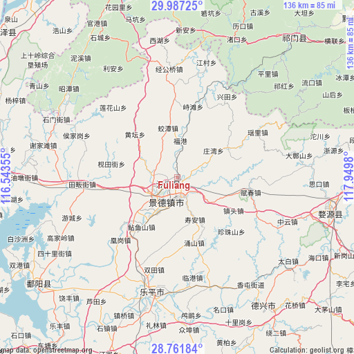
Fuliang GPS coordinates[2]
29° 22' 35.004" North, 117° 14' 48.012" East
| Map corner | latitude | longitude |
|---|---|---|
| Upper-left | 29.98725°, | 116.54355° |
| Center: | 29.37639°, | 117.24667° |
| Lower-right: | 28.76184°, | 117.9498° |
| Map W x H: | 136.3×136.3 km | = 84.7×84.7mi |
| max Lat: | 53.31946° ⇑61% North |
| Fuliang: | 29.37639° |
| min Lat: | ⇓39% South 18.22056° |
| min Long | Fuliang | max Long |
| 75.07348° | 117.24667° | 134.28917° |
| W 67.5%⇐ | ⇒32.5% E |
Elevation
Elevation of Fuliang is 48 m = 157 ft, and this is 436.8 m = 1433 ft below average elevation for this country.
| Max E: |
5622 m = 18445 ft | 71% |
| Avg. | 484.8 m = 1591 ft | |
| Fuliang | 48 m = 157 ft | |
Min E: |
-3 m = -10 ft | 29% |
See also: China elevation on elevation.city.
Geographical zone
Fuliang is located in North temperate zone (between Tropic of Cancer and the Arctic Circle). Distance of this Northern Tropic circle is 660.4 km =410.4 mi to South.| Distance of | km | miles | from Fuliang |
|---|---|---|---|
| North Pole | 6740.7 | 4188.5 | to North |
| Arctic Circle | 4134.8 | 2569.2 | to North |
| Tropic Cancer | 660.4 | 410.4 | to South |
| Equator | 3266.3 | 2029.6 | to South |


Nearby cities:
15 places around Fuliang: (largest is in red/bold)
• Ehu
22.5 km =14 mi,  60°
60°
• Hetang
24.5 km =15.2 mi,  205°
205°
• Hongyuan
11.1 km =6.9 mi,  236°
236°
• Huangtan
23 km =14.3 mi,  314°
314°
• Jiaotan
19.6 km =12.2 mi,  350°
350°
• Jingcheng
10.6 km =6.6 mi,  195°
195°
• Jingdezhen
9.8 km =6.1 mi, 202°
• Jinpanling
24.8 km =15.4 mi,  259°
259°
• Lümeng
13.9 km =8.6 mi, 211°
• Nianyushan
23.4 km =14.5 mi,  216°
216°
• Sanlong
9.9 km =6.2 mi,  275°
275°
• Wanggang
6.7 km =4.2 mi,  78°
78°
• Xianghu
8.8 km =5.5 mi,  130°
130°
• Zangwan
17.6 km =10.9 mi,  54°
54°
• Zhentou
24.7 km =15.3 mi,  119°
119°
Sources, notices
• [Note1] Compared only with cities in China existing in our database
• [Src1] Map data: © OpenStreetMap contributors (CC-BY-SA)
• [Src2] Other city data from geonames.org with taken over terms of usage.
• [Src3] Geographical zone / Annual Mean Temperature by Robert A. Rohde @ Wikipedia
