Wanggang geodata
Wanggang (Jiangxi) is a seat of a fourth-order administrative division; located in China in Asia/Shanghai (GMT+8) time zone. In our database, there are 1268 cities with bigger population. Compared to other cities in China, 60.9% of cities are located further ↑North; 67.9% of cities are located further ←West and 69.2% of cities have higher elevation than Wanggang. Note1


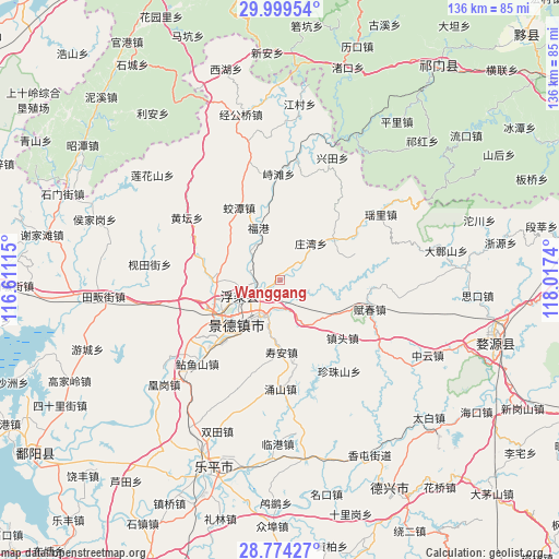
Wanggang GPS coordinates[2]
29° 23' 19.5" North, 117° 18' 51.372" East
| Map corner | latitude | longitude |
|---|---|---|
| Upper-left | 29.99954°, | 116.61115° |
| Center: | 29.38875°, | 117.31427° |
| Lower-right: | 28.77427°, | 118.0174° |
| Map W x H: | 136.2×136.2 km | = 84.6×84.6mi |
| max Lat: | 53.31946° ⇑60.9% North |
| Wanggang: | 29.38875° |
| min Lat: | ⇓39.1% South 18.22056° |
| min Long | Wanggang | max Long |
| 75.07348° | 117.31427° | 134.28917° |
| W 67.9%⇐ | ⇒32.1% E |
Elevation
Elevation of Wanggang is 55 m = 180 ft, and this is 429.8 m = 1410 ft below average elevation for this country.
| Max E: |
5622 m = 18445 ft | 69.2% |
| Avg. | 484.8 m = 1591 ft | |
| Wanggang | 55 m = 180 ft | |
Min E: |
-3 m = -10 ft | 30.8% |
See also: China elevation on elevation.city.
Geographical zone
Wanggang is located in North temperate zone (between Tropic of Cancer and the Arctic Circle). Distance of this Northern Tropic circle is 661.8 km =411.2 mi to South.| Distance of | km | miles | from Wanggang |
|---|---|---|---|
| North Pole | 6739.3 | 4187.6 | to North |
| Arctic Circle | 4133.5 | 2568.4 | to North |
| Tropic Cancer | 661.8 | 411.2 | to South |
| Equator | 3267.7 | 2030.5 | to South |


Nearby cities:
15 places around Wanggang: (largest is in red/bold)
• Ehu
16.2 km =10.1 mi,  53°
53°
• Fuchun
23.3 km =14.5 mi,  107°
107°
• Fuliang
6.7 km =4.2 mi,  258°
258°
• Hongyuan
17.6 km =10.9 mi,  244°
244°
• Jiaotan
20.5 km =12.7 mi,  331°
331°
• Jingcheng
14.9 km =9.3 mi,  218°
218°
• Jingdezhen
14.7 km =9.1 mi, 224°
• Lümeng
19.2 km =11.9 mi,  226°
226°
• Sanlong
16.4 km =10.2 mi,  268°
268°
• Xianghu
7 km =4.3 mi,  178°
178°
• Yongshan
26.6 km =16.5 mi, 179°
• Zangwan
11.9 km =7.4 mi,  40°
40°
• Zhentou
20.2 km =12.6 mi,  132°
132°
• Zhenzhushan
26.4 km =16.4 mi,  147°
147°
• Zhitan
25.8 km =16 mi,  358°
358°
Sources, notices
• [Note1] Compared only with cities in China existing in our database
• [Src1] Map data: © OpenStreetMap contributors (CC-BY-SA)
• [Src2] Other city data from geonames.org with taken over terms of usage.
• [Src3] Geographical zone / Annual Mean Temperature by Robert A. Rohde @ Wikipedia
