Jincheng geodata
Jincheng (Shanxi) is a seat of a second-order administrative division; located in China in Asia/Shanghai (GMT+8) time zone. With population of 332,650 people, there are 170 cities with bigger population in this country. Compared to other cities in China, 76% of cities are located further ↓South; 58.5% of cities are located further →East and 80.3% of cities have lower elevation than Jincheng. Note1


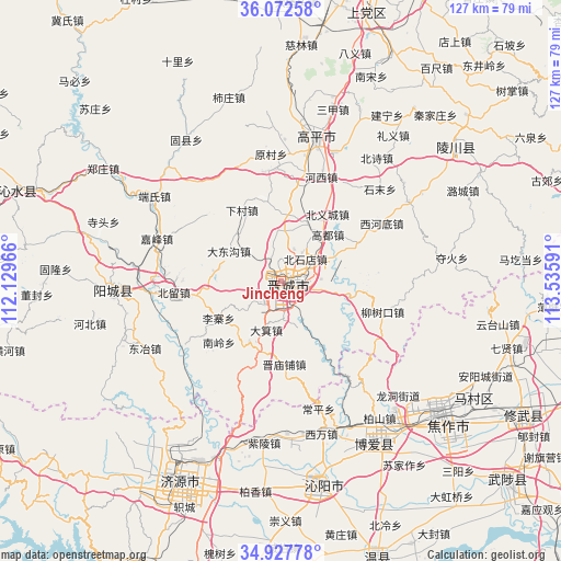
Jincheng GPS coordinates[2]
35° 30' 7.992" North, 112° 49' 58.008" East
| Map corner | latitude | longitude |
|---|---|---|
| Upper-left | 36.07258°, | 112.12966° |
| Center: | 35.50222°, | 112.83278° |
| Lower-right: | 34.92778°, | 113.53591° |
| Map W x H: | 127.3×127.3 km | = 79.1×79.1mi |
| max Lat: | 53.31946° ⇑24% North |
| Jincheng: | 35.50222° |
| min Lat: | ⇓76% South 18.22056° |
| min Long | Jincheng | max Long |
| 75.07348° | 112.83278° | 134.28917° |
| W 41.5%⇐ | ⇒58.5% E |
Elevation
Elevation of Jincheng is 711 m = 2333 ft, and this is 226.2 m = 742 ft above average elevation for this country.
| Max E: |
5622 m = 18445 ft | 19.7% |
| Jincheng | 711 m 2333 ft | |
| Avg. | 484.8 m = 1591 ft | |
Min E: |
-3 m = -10 ft | 80.3% |
See also: Jincheng elevation on elevation.city.
Geographical zone
Jincheng is located in North temperate zone (between Tropic of Cancer and the Arctic Circle). Distance of this Northern Tropic circle is 1341.6 km =833.6 mi to South.| Distance of | km | miles | from Jincheng |
|---|---|---|---|
| North Pole | 6059.6 | 3765.3 | to North |
| Arctic Circle | 3453.7 | 2146 | to North |
| Tropic Cancer | 1341.6 | 833.6 | to South |
| Equator | 3947.5 | 2452.9 | to South |


Nearby cities:
15 places around Jincheng: (largest is in red/bold)
• Beishidian
7.5 km =4.7 mi,  47°
47°
• Changping
30.3 km =18.8 mi,  163°
163°
• Chongwen
48.4 km =30.1 mi, 51°
• Handian
63.4 km =39.4 mi,  17°
17°
• Jiaozuo
46.6 km =29 mi,  128°
128°
• Jincun
6.6 km =4.1 mi,  90°
90°
• Jiyuan
51.3 km =31.9 mi,  206°
206°
• Longgang
64.5 km =40.1 mi,  288°
288°
• Nancun
5.4 km =3.4 mi,  217°
217°
• Qinghua
42.9 km =26.7 mi,  151°
151°
• Tanbei
47.1 km =29.3 mi,  168°
168°
• Xiuwu Chengguanzhen
62.6 km =38.9 mi,  118°
118°
• Xixiang
37.9 km =23.5 mi,  175°
175°
• Yangcheng
38.8 km =24.1 mi,  268°
268°
• Zhongzhan
41.5 km =25.8 mi, 134°
Sources, notices
• [Note1] Compared only with cities in China existing in our database
• [Src1] Map data: © OpenStreetMap contributors (CC-BY-SA)
• [Src2] Other city data from geonames.org with taken over terms of usage.
• [Src3] Geographical zone / Annual Mean Temperature by Robert A. Rohde @ Wikipedia
