Xixiang geodata
Xixiang (Henan) is a populated place; located in China in Asia/Shanghai (GMT+8) time zone. With population of 60,745 people, there are 722 cities with bigger population in this country. Compared to other cities in China, 75.4% of cities are located further ↓South; 58.3% of cities are located further →East and 54.9% of cities have higher elevation than Xixiang. Note1


Xixiang GPS coordinates[2]
35° 9' 46.008" North, 112° 51' 54" East
| Map corner | latitude | longitude |
|---|---|---|
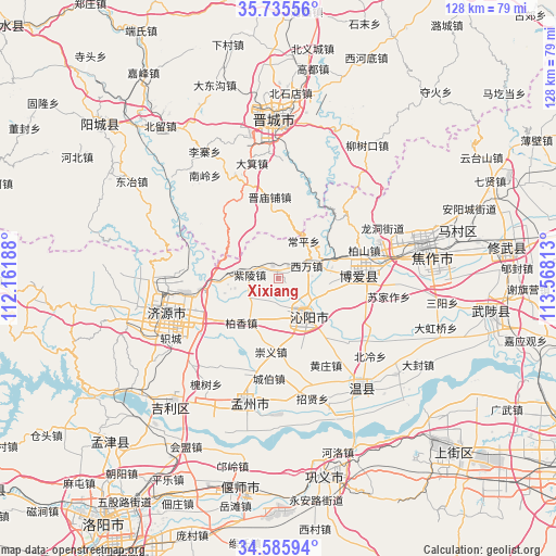
| Upper-left | 35.73556°, | 112.16188° |
| Center: | 35.16278°, | 112.865° |
| Lower-right: | 34.58594°, | 113.56813° |
| Map W x H: | 127.8×127.8 km | = 79.4×79.4mi |
| max Lat: | 53.31946° ⇑24.6% North |
| Xixiang: | 35.16278° |
| min Lat: | ⇓75.4% South 18.22056° |
| min Long | Xixiang | max Long |
| 75.07348° | 112.865° | 134.28917° |
| W 41.7%⇐ | ⇒58.3% E |
Elevation
Elevation of Xixiang is 132 m = 433 ft, and this is 352.8 m = 1157 ft below average elevation for this country.
| Max E: |
5622 m = 18445 ft | 54.9% |
| Avg. | 484.8 m = 1591 ft | |
| Xixiang | 132 m = 433 ft | |
Min E: |
-3 m = -10 ft | 45.1% |
See also: Xixiang elevation on elevation.city.
Geographical zone
Xixiang is located in North temperate zone (between Tropic of Cancer and the Arctic Circle). Distance of this Northern Tropic circle is 1303.8 km =810.1 mi to South.| Distance of | km | miles | from Xixiang |
|---|---|---|---|
| North Pole | 6097.3 | 3788.7 | to North |
| Arctic Circle | 3491.4 | 2169.5 | to North |
| Tropic Cancer | 1303.8 | 810.1 | to South |
| Equator | 3909.7 | 2429.4 | to South |


Nearby cities:
15 places around Xixiang: (largest is in red/bold)
• Beishidian
42.9 km =26.7 mi,  3°
3°
• Changping
10.3 km =6.4 mi,  32°
32°
• Daqinglu
38.9 km =24.2 mi,  221°
221°
• Huichang
29.7 km =18.5 mi,  194°
194°
• Jiaozuo
34.5 km =21.4 mi,  75°
75°
• Jincheng
37.9 km =23.5 mi,  355°
355°
• Jincun
37.9 km =23.5 mi,  5°
5°
• Jiyuan
27.2 km =16.9 mi,  252°
252°
• Mucheng
48.3 km =30 mi,  98°
98°
• Nancun
34 km =21.1 mi,  349°
349°
• Qinghua
17.9 km =11.1 mi,  89°
89°
• Tanbei
10.7 km =6.6 mi,  140°
140°
• Wenquan
31.6 km =19.6 mi, 143°
• Zhongzhan
28.2 km =17.5 mi,  71°
71°
• Zijinglu
45.8 km =28.5 mi,  167°
167°
Sources, notices
• [Note1] Compared only with cities in China existing in our database
• [Src1] Map data: © OpenStreetMap contributors (CC-BY-SA)
• [Src2] Other city data from geonames.org with taken over terms of usage.
• [Src3] Geographical zone / Annual Mean Temperature by Robert A. Rohde @ Wikipedia
