Shuangfu geodata
Shuangfu (Chongqing) is a seat of a fourth-order administrative division; located in China in Asia/Shanghai (GMT+8) time zone. In our database, there are 1268 cities with bigger population. Compared to other cities in China, 60.7% of cities are located further ↑North; 85.9% of cities are located further →East and 66.8% of cities have lower elevation than Shuangfu. Note1


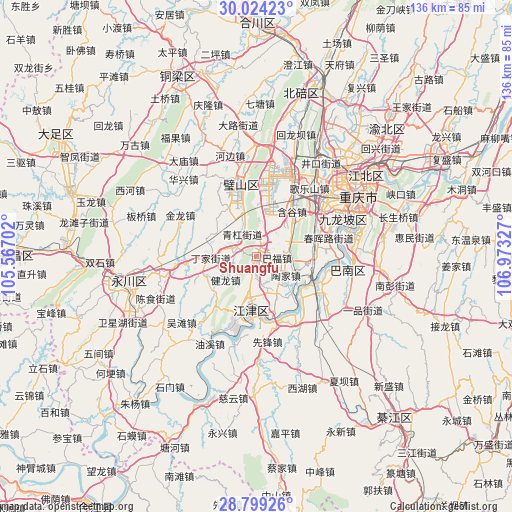
Shuangfu GPS coordinates[2]
29° 24' 48.924" North, 106° 16' 12.504" East
| Map corner | latitude | longitude |
|---|---|---|
| Upper-left | 30.02423°, | 105.56702° |
| Center: | 29.41359°, | 106.27014° |
| Lower-right: | 28.79926°, | 106.97327° |
| Map W x H: | 136.2×136.2 km | = 84.6×84.6mi |
| max Lat: | 53.31946° ⇑60.7% North |
| Shuangfu: | 29.41359° |
| min Lat: | ⇓39.3% South 18.22056° |
| min Long | Shuangfu | max Long |
| 75.07348° | 106.27014° | 134.28917° |
| W 14.1%⇐ | ⇒85.9% E |
Elevation
Elevation of Shuangfu is 356 m = 1168 ft, and this is 128.8 m = 423 ft below average elevation for this country.
| Max E: |
5622 m = 18445 ft | 33.2% |
| Avg. | 484.8 m = 1591 ft | |
| Shuangfu | 356 m = 1168 ft | |
Min E: |
-3 m = -10 ft | 66.8% |
See also: China elevation on elevation.city.
Geographical zone
Shuangfu is located in North temperate zone (between Tropic of Cancer and the Arctic Circle). Distance of this Northern Tropic circle is 664.6 km =413 mi to South.| Distance of | km | miles | from Shuangfu |
|---|---|---|---|
| North Pole | 6736.6 | 4185.9 | to North |
| Arctic Circle | 4130.7 | 2566.7 | to North |
| Tropic Cancer | 664.6 | 413 | to South |
| Equator | 3270.5 | 2032.2 | to South |


Nearby cities:
15 places around Shuangfu: (largest is in red/bold)
• Baishiyi
13.8 km =8.6 mi,  50°
50°
• Degan
15.5 km =9.6 mi,  193°
193°
• Dingjia
12.4 km =7.7 mi,  267°
267°
• Guangpu
14.9 km =9.3 mi,  234°
234°
• Jianlong
10.3 km =6.4 mi, 233°
• Jijiang
13.9 km =8.6 mi, 188°
• Jinfeng
11.6 km =7.2 mi,  27°
27°
• Qinggang
6.9 km =4.3 mi,  331°
331°
• Shiban
8.1 km =5 mi,  80°
80°
• Taojia
6.7 km =4.2 mi,  132°
132°
• Tiaodeng
15.2 km =9.4 mi,  93°
93°
• Xipeng
14.2 km =8.8 mi,  159°
159°
• Zengjia
15.5 km =9.6 mi,  9°
9°
• Zhengxing
14.5 km =9 mi,  289°
289°
• Zouma
6.8 km =4.2 mi,  20°
20°
Sources, notices
• [Note1] Compared only with cities in China existing in our database
• [Src1] Map data: © OpenStreetMap contributors (CC-BY-SA)
• [Src2] Other city data from geonames.org with taken over terms of usage.
• [Src3] Geographical zone / Annual Mean Temperature by Robert A. Rohde @ Wikipedia
