Bozhou geodata
Bozhou (Anhui) is a seat of a second-order administrative division; located in China in Asia/Shanghai (GMT+8) time zone. With population of 174,140 people, there are 257 cities with bigger population in this country. Compared to other cities in China, 69.6% of cities are located further ↓South; 58.6% of cities are located further ←West and 73.7% of cities have higher elevation than Bozhou. Note1


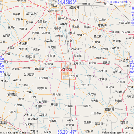
Bozhou GPS coordinates[2]
33° 52' 37.992" North, 115° 46' 13.008" East
| Map corner | latitude | longitude |
|---|---|---|
| Upper-left | 34.45898°, | 115.06716° |
| Center: | 33.87722°, | 115.77028° |
| Lower-right: | 33.29147°, | 116.47341° |
| Map W x H: | 129.8×129.8 km | = 80.7×80.7mi |
| max Lat: | 53.31946° ⇑30.4% North |
| Bozhou: | 33.87722° |
| min Lat: | ⇓69.6% South 18.22056° |
| min Long | Bozhou | max Long |
| 75.07348° | 115.77028° | 134.28917° |
| W 58.6%⇐ | ⇒41.4% E |
Elevation
Elevation of Bozhou is 40 m = 131 ft, and this is 444.8 m = 1459 ft below average elevation for this country.
| Max E: |
5622 m = 18445 ft | 73.7% |
| Avg. | 484.8 m = 1591 ft | |
| Bozhou | 40 m = 131 ft | |
Min E: |
-3 m = -10 ft | 26.3% |
See also: Bozhou elevation on elevation.city.
Geographical zone
Bozhou is located in North temperate zone (between Tropic of Cancer and the Arctic Circle). Distance of this Northern Tropic circle is 1160.9 km =721.3 mi to South.| Distance of | km | miles | from Bozhou |
|---|---|---|---|
| North Pole | 6240.3 | 3877.5 | to North |
| Arctic Circle | 3634.4 | 2258.3 | to North |
| Tropic Cancer | 1160.9 | 721.3 | to South |
| Equator | 3766.8 | 2340.6 | to South |


Nearby cities:
15 places around Bozhou: (largest is in red/bold)
• Chezhan
62.9 km =39.1 mi,  21°
21°
• Dangcheng
82.8 km =51.4 mi,  42°
42°
• Dongcheng
82.1 km =51 mi,  230°
230°
• Guoyang Chengguanzhen
59.4 km =36.9 mi,  134°
134°
• Huaiyang Chengguanzhen
83.5 km =51.9 mi,  258°
258°
• Jieshou
78.1 km =48.5 mi,  209°
209°
• Jishui
37.8 km =23.5 mi,  244°
244°
• Ningling Chengguanzhen
76.1 km =47.3 mi,  326°
326°
• Shangqiu
64.6 km =40.1 mi,  350°
350°
• Taihe Chengguanzhen
79.9 km =49.6 mi,  188°
188°
• Xiayi Chengguanzhen
51.1 km =31.8 mi, 38°
• Xiguan
28.1 km =17.5 mi,  267°
267°
• Xincheng
60.7 km =37.7 mi, 243°
• Yanji
63.6 km =39.5 mi,  81°
81°
• Zhecheng Chengguanzhen
48.8 km =30.3 mi,  301°
301°
Sources, notices
• [Note1] Compared only with cities in China existing in our database
• [Src1] Map data: © OpenStreetMap contributors (CC-BY-SA)
• [Src2] Other city data from geonames.org with taken over terms of usage.
• [Src3] Geographical zone / Annual Mean Temperature by Robert A. Rohde @ Wikipedia
