Jiapu geodata
Jiapu (Zhejiang) is a seat of a fourth-order administrative division; located in China in Asia/Shanghai (GMT+8) time zone. In our database, there are 1268 cities with bigger population. Compared to other cities in China, 55.6% of cities are located further ↓South; 81.5% of cities are located further ←West and 95.9% of cities have higher elevation than Jiapu. Note1


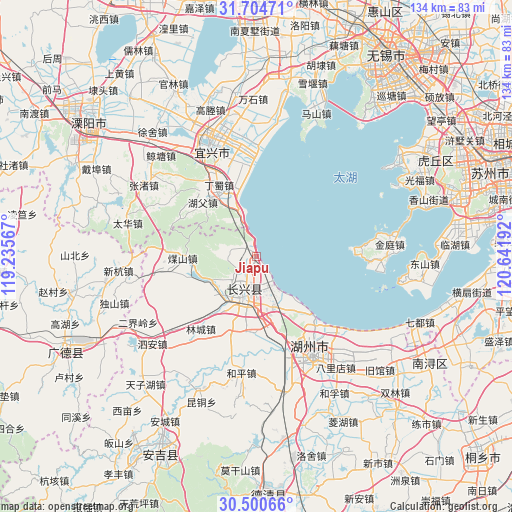
Jiapu GPS coordinates[2]
31° 6' 16.524" North, 119° 56' 19.644" East
| Map corner | latitude | longitude |
|---|---|---|
| Upper-left | 31.70471°, | 119.23567° |
| Center: | 31.10459°, | 119.93879° |
| Lower-right: | 30.50066°, | 120.64192° |
| Map W x H: | 133.9×133.9 km | = 83.2×83.2mi |
| max Lat: | 53.31946° ⇑44.4% North |
| Jiapu: | 31.10459° |
| min Lat: | ⇓55.6% South 18.22056° |
| min Long | Jiapu | max Long |
| 75.07348° | 119.93879° | 134.28917° |
| W 81.5%⇐ | ⇒18.5% E |
Elevation
Elevation of Jiapu is 6 m = 20 ft, and this is 478.8 m = 1571 ft below average elevation for this country.
| Max E: |
5622 m = 18445 ft | 95.9% |
| Avg. | 484.8 m = 1591 ft | |
| Jiapu | 6 m = 20 ft | |
Min E: |
-3 m = -10 ft | 4.1% |
See also: China elevation on elevation.city.
Geographical zone
Jiapu is located in North temperate zone (between Tropic of Cancer and the Arctic Circle). Distance of this Northern Tropic circle is 852.6 km =529.8 mi to South.| Distance of | km | miles | from Jiapu |
|---|---|---|---|
| North Pole | 6548.6 | 4069.1 | to North |
| Arctic Circle | 3942.7 | 2449.9 | to North |
| Tropic Cancer | 852.6 | 529.8 | to South |
| Equator | 3458.5 | 2149 | to South |


Nearby cities:
15 places around Jiapu: (largest is in red/bold)
• Baique
25.5 km =15.8 mi,  143°
143°
• Baixian
24.1 km =15 mi,  273°
273°
• Dingshu
19 km =11.8 mi,  333°
333°
• Hongqiao
13.5 km =8.4 mi,  161°
161°
• Hongxingqiao
21.2 km =13.2 mi,  198°
198°
• Huaikan
24.8 km =15.4 mi,  261°
261°
• Lijiaxiang
17.5 km =10.9 mi,  168°
168°
• Lincheng
23.9 km =14.9 mi,  217°
217°
• Lüshan
19.5 km =12.1 mi,  185°
185°
• Meishan
19.4 km =12.1 mi, 269°
• Nangaoqiao
25.4 km =15.8 mi, 143°
• Sujiazhuang
28.6 km =17.8 mi,  153°
153°
• Xiaopu
13.2 km =8.2 mi,  231°
231°
• Xinzhuang
27.9 km =17.3 mi,  353°
353°
• Zhicheng
11.2 km =7 mi, 194°
Sources, notices
• [Note1] Compared only with cities in China existing in our database
• [Src1] Map data: © OpenStreetMap contributors (CC-BY-SA)
• [Src2] Other city data from geonames.org with taken over terms of usage.
• [Src3] Geographical zone / Annual Mean Temperature by Robert A. Rohde @ Wikipedia
