Lincheng geodata
Lincheng (Zhejiang) is a seat of a fourth-order administrative division; located in China in Asia/Shanghai (GMT+8) time zone. In our database, there are 1268 cities with bigger population. Compared to other cities in China, 54.3% of cities are located further ↓South; 80.5% of cities are located further ←West and 88.7% of cities have higher elevation than Lincheng. Note1


Lincheng GPS coordinates[2]
30° 56' 1.464" North, 119° 47' 12.552" East
| Map corner | latitude | longitude |
|---|---|---|
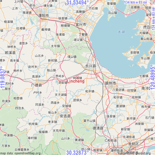
| Upper-left | 31.53494°, | 119.0837° |
| Center: | 30.93374°, | 119.78682° |
| Lower-right: | 30.32873°, | 120.48995° |
| Map W x H: | 134.1×134.1 km | = 83.3×83.3mi |
| max Lat: | 53.31946° ⇑45.7% North |
| Lincheng: | 30.93374° |
| min Lat: | ⇓54.3% South 18.22056° |
| min Long | Lincheng | max Long |
| 75.07348° | 119.78682° | 134.28917° |
| W 80.5%⇐ | ⇒19.5% E |
Elevation
Elevation of Lincheng is 11 m = 36 ft, and this is 473.8 m = 1554 ft below average elevation for this country.
| Max E: |
5622 m = 18445 ft | 88.7% |
| Avg. | 484.8 m = 1591 ft | |
| Lincheng | 11 m = 36 ft | |
Min E: |
-3 m = -10 ft | 11.3% |
See also: China elevation on elevation.city.
Geographical zone
Lincheng is located in North temperate zone (between Tropic of Cancer and the Arctic Circle). Distance of this Northern Tropic circle is 833.6 km =518 mi to South.| Distance of | km | miles | from Lincheng |
|---|---|---|---|
| North Pole | 6567.6 | 4080.9 | to North |
| Arctic Circle | 3961.7 | 2461.7 | to North |
| Tropic Cancer | 833.6 | 518 | to South |
| Equator | 3439.5 | 2137.2 | to South |


Nearby cities:
15 places around Lincheng: (largest is in red/bold)
• Baixian
22.6 km =14 mi,  334°
334°
• Erjieling
16.6 km =10.3 mi,  275°
275°
• Gaoyu
21.2 km =13.2 mi,  233°
233°
• Heping
15.6 km =9.7 mi,  137°
137°
• Hongqiao
19.9 km =12.4 mi,  71°
71°
• Hongxingqiao
7.9 km =4.9 mi,  98°
98°
• Huaikan
18.2 km =11.3 mi, 326°
• Jiapu
23.9 km =14.9 mi,  37°
37°
• Kuntong
19.2 km =11.9 mi,  179°
179°
• Lijiaxiang
18.1 km =11.2 mi,  83°
83°
• Lüshan
12.5 km =7.8 mi,  91°
91°
• Meishan
19.5 km =12.1 mi,  345°
345°
• Si’an
13.3 km =8.3 mi,  252°
252°
• Xiaopu
11.5 km =7.1 mi,  21°
21°
• Zhicheng
14.2 km =8.8 mi,  54°
54°
Sources, notices
• [Note1] Compared only with cities in China existing in our database
• [Src1] Map data: © OpenStreetMap contributors (CC-BY-SA)
• [Src2] Other city data from geonames.org with taken over terms of usage.
• [Src3] Geographical zone / Annual Mean Temperature by Robert A. Rohde @ Wikipedia
