Meishan geodata
Meishan (Zhejiang) is a seat of a fourth-order administrative division; located in China in Asia/Shanghai (GMT+8) time zone. In our database, there are 1268 cities with bigger population. Compared to other cities in China, 55.6% of cities are located further ↓South; 80.2% of cities are located further ←West and 72.3% of cities have higher elevation than Meishan. Note1


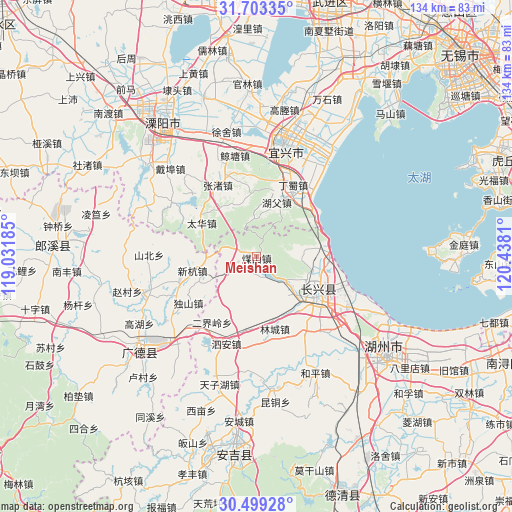
Meishan GPS coordinates[2]
31° 6' 11.592" North, 119° 44' 5.892" East
| Map corner | latitude | longitude |
|---|---|---|
| Upper-left | 31.70335°, | 119.03185° |
| Center: | 31.10322°, | 119.73497° |
| Lower-right: | 30.49928°, | 120.4381° |
| Map W x H: | 133.9×133.9 km | = 83.2×83.2mi |
| max Lat: | 53.31946° ⇑44.4% North |
| Meishan: | 31.10322° |
| min Lat: | ⇓55.6% South 18.22056° |
| min Long | Meishan | max Long |
| 75.07348° | 119.73497° | 134.28917° |
| W 80.2%⇐ | ⇒19.8% E |
Elevation
Elevation of Meishan is 44 m = 144 ft, and this is 440.8 m = 1446 ft below average elevation for this country.
| Max E: |
5622 m = 18445 ft | 72.3% |
| Avg. | 484.8 m = 1591 ft | |
| Meishan | 44 m = 144 ft | |
Min E: |
-3 m = -10 ft | 27.7% |
See also: China elevation on elevation.city.
Geographical zone
Meishan is located in North temperate zone (between Tropic of Cancer and the Arctic Circle). Distance of this Northern Tropic circle is 852.4 km =529.7 mi to South.| Distance of | km | miles | from Meishan |
|---|---|---|---|
| North Pole | 6548.7 | 4069.2 | to North |
| Arctic Circle | 3942.8 | 2449.9 | to North |
| Tropic Cancer | 852.4 | 529.7 | to South |
| Equator | 3458.4 | 2148.9 | to South |


Nearby cities:
15 places around Meishan: (largest is in red/bold)
• Baixian
5 km =3.1 mi,  288°
288°
• Dingshu
20.3 km =12.6 mi,  32°
32°
• Erjieling
20.7 km =12.9 mi,  213°
213°
• Hongxingqiao
23.7 km =14.7 mi,  147°
147°
• Huaikan
6.3 km =3.9 mi,  234°
234°
• Jiapu
19.4 km =12.1 mi,  89°
89°
• Lincheng
19.5 km =12.1 mi,  165°
165°
• Liudong
22.1 km =13.7 mi,  248°
248°
• Lüshan
26 km =16.2 mi,  137°
137°
• Si’an
24.1 km =15 mi,  198°
198°
• Taihua
16.9 km =10.5 mi,  301°
301°
• Xiaopu
12.2 km =7.6 mi,  131°
131°
• Xinhang
17 km =10.6 mi,  257°
257°
• Zhangzhu
20.9 km =13 mi,  331°
331°
• Zhicheng
19.7 km =12.2 mi,  122°
122°
Sources, notices
• [Note1] Compared only with cities in China existing in our database
• [Src1] Map data: © OpenStreetMap contributors (CC-BY-SA)
• [Src2] Other city data from geonames.org with taken over terms of usage.
• [Src3] Geographical zone / Annual Mean Temperature by Robert A. Rohde @ Wikipedia
