Daba geodata
Daba (Guangdong) is a seat of a fourth-order administrative division; located in China in Asia/Shanghai (GMT+8) time zone. In our database, there are 1268 cities with bigger population. Compared to other cities in China, 97.1% of cities are located further ↑North; 62.9% of cities are located further →East and 71.9% of cities have higher elevation than Daba. Note1


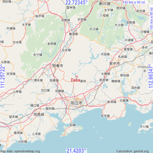
Daba GPS coordinates[2]
22° 4' 24.168" North, 111° 57' 37.224" East
| Map corner | latitude | longitude |
|---|---|---|
| Upper-left | 22.72345°, | 111.25722° |
| Center: | 22.07338°, | 111.96034° |
| Lower-right: | 21.4203°, | 112.66347° |
| Map W x H: | 144.9×144.9 km | = 90×90mi |
| max Lat: | 53.31946° ⇑97.1% North |
| Daba: | 22.07338° |
| min Lat: | ⇓2.9% South 18.22056° |
| min Long | Daba | max Long |
| 75.07348° | 111.96034° | 134.28917° |
| W 37.1%⇐ | ⇒62.9% E |
Elevation
Elevation of Daba is 45 m = 148 ft, and this is 439.8 m = 1443 ft below average elevation for this country.
| Max E: |
5622 m = 18445 ft | 71.9% |
| Avg. | 484.8 m = 1591 ft | |
| Daba | 45 m = 148 ft | |
Min E: |
-3 m = -10 ft | 28.1% |
See also: China elevation on elevation.city.
Geographical zone
Daba is located in North Torrid zone (between Equator and Tropic of Cancer). Distance of this Northern Tropic circle is 151.6 km =94.2 mi to North.| Distance of | km | miles | from Daba |
|---|---|---|---|
| North Pole | 7552.7 | 4693 | to North |
| Arctic Circle | 4946.8 | 3073.8 | to North |
| Tropic Cancer | 151.6 | 94.2 | to North |
| Equator | 2454.3 | 1525 | to South |


Nearby cities:
15 places around Daba: (largest is in red/bold)
• Baisha
24 km =14.9 mi,  201°
201°
• Beiguan
19.1 km =11.9 mi,  144°
144°
• Chengxi
27.6 km =17.1 mi,  184°
184°
• Chuncheng
21 km =13 mi,  301°
301°
• Dongcheng
21.9 km =13.6 mi,  166°
166°
• Ganglie
24.9 km =15.5 mi, 179°
• Gangmei
21.8 km =13.5 mi,  261°
261°
• Heshan
21.1 km =13.1 mi,  124°
124°
• Heshui
27.3 km =17 mi,  338°
338°
• Naji
21.2 km =13.2 mi,  75°
75°
• Nalong
25.9 km =16.1 mi,  98°
98°
• Shuangjie
23.4 km =14.5 mi,  231°
231°
• Tangping
5.3 km =3.3 mi,  209°
209°
• Yangchun
21 km =13 mi, 299°
• Yangjiang
24.2 km =15 mi, 179°
Sources, notices
• [Note1] Compared only with cities in China existing in our database
• [Src1] Map data: © OpenStreetMap contributors (CC-BY-SA)
• [Src2] Other city data from geonames.org with taken over terms of usage.
• [Src3] Geographical zone / Annual Mean Temperature by Robert A. Rohde @ Wikipedia
