Huishangang geodata
Huishangang (Hunan) is a seat of a fourth-order administrative division; located in China in Asia/Shanghai (GMT+8) time zone. In our database, there are 1268 cities with bigger population. Compared to other cities in China, 71.6% of cities are located further ↑North; 61.4% of cities are located further →East and 60.3% of cities have higher elevation than Huishangang. Note1


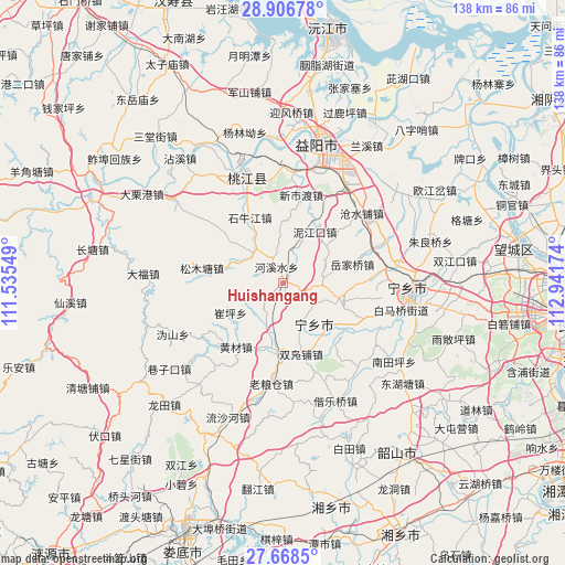
Huishangang GPS coordinates[2]
28° 17' 21.984" North, 112° 14' 18.996" East
| Map corner | latitude | longitude |
|---|---|---|
| Upper-left | 28.90678°, | 111.53549° |
| Center: | 28.28944°, | 112.23861° |
| Lower-right: | 27.6685°, | 112.94174° |
| Map W x H: | 137.7×137.7 km | = 85.6×85.6mi |
| max Lat: | 53.31946° ⇑71.6% North |
| Huishangang: | 28.28944° |
| min Lat: | ⇓28.4% South 18.22056° |
| min Long | Huishangang | max Long |
| 75.07348° | 112.23861° | 134.28917° |
| W 38.6%⇐ | ⇒61.4% E |
Elevation
Elevation of Huishangang is 97 m = 318 ft, and this is 387.8 m = 1272 ft below average elevation for this country.
| Max E: |
5622 m = 18445 ft | 60.3% |
| Avg. | 484.8 m = 1591 ft | |
| Huishangang | 97 m = 318 ft | |
Min E: |
-3 m = -10 ft | 39.7% |
See also: China elevation on elevation.city.
Geographical zone
Huishangang is located in North temperate zone (between Tropic of Cancer and the Arctic Circle). Distance of this Northern Tropic circle is 539.6 km =335.3 mi to South.| Distance of | km | miles | from Huishangang |
|---|---|---|---|
| North Pole | 6861.6 | 4263.6 | to North |
| Arctic Circle | 4255.7 | 2644.4 | to North |
| Tropic Cancer | 539.6 | 335.3 | to South |
| Equator | 3145.5 | 1954.5 | to South |


Nearby cities:
15 places around Huishangang: (largest is in red/bold)
• Cangshuipu
25.6 km =15.9 mi,  49°
49°
• Cuiping
14.6 km =9.1 mi,  248°
248°
• Heshan
34.4 km =21.4 mi,  18°
18°
• Huangcai
18.7 km =11.6 mi,  217°
217°
• Huitang
34.5 km =21.4 mi,  164°
164°
• Laoliangcang
24.3 km =15.1 mi,  190°
190°
• Shiniujiang
17.8 km =11.1 mi,  334°
334°
• Songmutang
15.7 km =9.8 mi,  282°
282°
• Taohuajiang
28.3 km =17.6 mi,  336°
336°
• Xiangzikou
34.7 km =21.6 mi,  233°
233°
• Xinshidu
22.6 km =14 mi,  10°
10°
• Yiyang
34.5 km =21.4 mi, 14°
• Yuejiaqiao
19.9 km =12.4 mi,  76°
76°
• Yujia’ao
10.9 km =6.8 mi,  167°
167°
• Yutan
31.7 km =19.7 mi,  96°
96°
Sources, notices
• [Note1] Compared only with cities in China existing in our database
• [Src1] Map data: © OpenStreetMap contributors (CC-BY-SA)
• [Src2] Other city data from geonames.org with taken over terms of usage.
• [Src3] Geographical zone / Annual Mean Temperature by Robert A. Rohde @ Wikipedia
