Yutan geodata
Yutan (Hunan) is a seat of a third-order administrative division; located in China in Asia/Shanghai (GMT+8) time zone. With population of 55,312 people, there are 789 cities with bigger population in this country. Compared to other cities in China, 71.8% of cities are located further ↑North; 59.8% of cities are located further →East and 69.7% of cities have higher elevation than Yutan. Note1


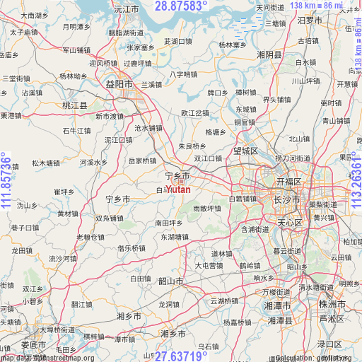
Yutan GPS coordinates[2]
28° 15' 29.916" North, 112° 33' 37.728" East
| Map corner | latitude | longitude |
|---|---|---|
| Upper-left | 28.87583°, | 111.85736° |
| Center: | 28.25831°, | 112.56048° |
| Lower-right: | 27.63719°, | 113.26361° |
| Map W x H: | 137.7×137.7 km | = 85.6×85.6mi |
| max Lat: | 53.31946° ⇑71.8% North |
| Yutan: | 28.25831° |
| min Lat: | ⇓28.2% South 18.22056° |
| min Long | Yutan | max Long |
| 75.07348° | 112.56048° | 134.28917° |
| W 40.2%⇐ | ⇒59.8% E |
Elevation
Elevation of Yutan is 53 m = 174 ft, and this is 431.8 m = 1417 ft below average elevation for this country.
| Max E: |
5622 m = 18445 ft | 69.7% |
| Avg. | 484.8 m = 1591 ft | |
| Yutan | 53 m = 174 ft | |
Min E: |
-3 m = -10 ft | 30.3% |
See also: Yutan elevation on elevation.city.
Geographical zone
Yutan is located in North temperate zone (between Tropic of Cancer and the Arctic Circle). Distance of this Northern Tropic circle is 536.1 km =333.1 mi to South.| Distance of | km | miles | from Yutan |
|---|---|---|---|
| North Pole | 6865 | 4265.7 | to North |
| Arctic Circle | 4259.1 | 2646.5 | to North |
| Tropic Cancer | 536.1 | 333.1 | to South |
| Equator | 3142 | 1952.3 | to South |


Nearby cities:
15 places around Yutan: (largest is in red/bold)
• Bairuopu
24.3 km =15.1 mi,  105°
105°
• Cangshuipu
23.6 km =14.7 mi,  328°
328°
• Gaotangling
27.8 km =17.3 mi,  64°
64°
• Huaminglou
23.5 km =14.6 mi,  167°
167°
• Huishangang
31.7 km =19.7 mi,  276°
276°
• Huitang
37.4 km =23.2 mi,  217°
217°
• Lianhua
25.6 km =15.9 mi,  127°
127°
• Oujiangcha
23.7 km =14.7 mi,  8°
8°
• Qiaokou
32 km =19.9 mi,  31°
31°
• Qiaoyi
39.4 km =24.5 mi, 63°
• Tongguan
32.7 km =20.3 mi,  47°
47°
• Wangyue
35 km =21.7 mi,  94°
94°
• Xinshidu
37.6 km =23.4 mi,  313°
313°
• Yuejiaqiao
14.5 km =9 mi,  303°
303°
• Yujia’ao
30 km =18.6 mi,  256°
256°
Sources, notices
• [Note1] Compared only with cities in China existing in our database
• [Src1] Map data: © OpenStreetMap contributors (CC-BY-SA)
• [Src2] Other city data from geonames.org with taken over terms of usage.
• [Src3] Geographical zone / Annual Mean Temperature by Robert A. Rohde @ Wikipedia
