Huitang geodata
Huitang (Hunan) is a seat of a fourth-order administrative division; located in China in Asia/Shanghai (GMT+8) time zone. In our database, there are 1268 cities with bigger population. Compared to other cities in China, 74.2% of cities are located further ↑North; 61% of cities are located further →East and 61.9% of cities have higher elevation than Huitang. Note1


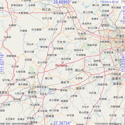
Huitang GPS coordinates[2]
27° 59' 24" North, 112° 19' 49.008" East
| Map corner | latitude | longitude |
|---|---|---|
| Upper-left | 28.60908°, | 111.62716° |
| Center: | 27.99°, | 112.33028° |
| Lower-right: | 27.36734°, | 113.03341° |
| Map W x H: | 138.1×138.1 km | = 85.8×85.8mi |
| max Lat: | 53.31946° ⇑74.2% North |
| Huitang: | 27.99° |
| min Lat: | ⇓25.8% South 18.22056° |
| min Long | Huitang | max Long |
| 75.07348° | 112.33028° | 134.28917° |
| W 39%⇐ | ⇒61% E |
Elevation
Elevation of Huitang is 88 m = 289 ft, and this is 396.8 m = 1302 ft below average elevation for this country.
| Max E: |
5622 m = 18445 ft | 61.9% |
| Avg. | 484.8 m = 1591 ft | |
| Huitang | 88 m = 289 ft | |
Min E: |
-3 m = -10 ft | 38.1% |
See also: China elevation on elevation.city.
Geographical zone
Huitang is located in North temperate zone (between Tropic of Cancer and the Arctic Circle). Distance of this Northern Tropic circle is 506.3 km =314.6 mi to South.| Distance of | km | miles | from Huitang |
|---|---|---|---|
| North Pole | 6894.9 | 4284.3 | to North |
| Arctic Circle | 4289 | 2665.1 | to North |
| Tropic Cancer | 506.3 | 314.6 | to South |
| Equator | 3112.2 | 1933.8 | to South |


Nearby cities:
15 places around Huitang: (largest is in red/bold)
• Cangshuipu
51.1 km =31.8 mi,  11°
11°
• Cuiping
35.9 km =22.3 mi,  320°
320°
• Huaminglou
28.7 km =17.8 mi,  75°
75°
• Huangcai
27.7 km =17.2 mi,  312°
312°
• Huishangang
34.5 km =21.4 mi,  344°
344°
• Laoliangcang
16.5 km =10.3 mi,  304°
304°
• Lianhua
45.1 km =28 mi,  71°
71°
• Longtian
39.1 km =24.3 mi,  274°
274°
• Loudi
43.6 km =27.1 mi,  229°
229°
• Songmutang
43.9 km =27.3 mi,  326°
326°
• Xiangxiang
34.8 km =21.6 mi,  145°
145°
• Xiangzikou
39 km =24.2 mi,  288°
288°
• Yuejiaqiao
39.2 km =24.4 mi,  15°
15°
• Yujia’ao
23.6 km =14.7 mi, 343°
• Yutan
37.4 km =23.2 mi,  37°
37°
Sources, notices
• [Note1] Compared only with cities in China existing in our database
• [Src1] Map data: © OpenStreetMap contributors (CC-BY-SA)
• [Src2] Other city data from geonames.org with taken over terms of usage.
• [Src3] Geographical zone / Annual Mean Temperature by Robert A. Rohde @ Wikipedia
