Huangze geodata
Huangze (Zhejiang) is a seat of a fourth-order administrative division; located in China in Asia/Shanghai (GMT+8) time zone. In our database, there are 1268 cities with bigger population. Compared to other cities in China, 58.8% of cities are located further ↑North; 87.4% of cities are located further ←West and 75.3% of cities have higher elevation than Huangze. Note1


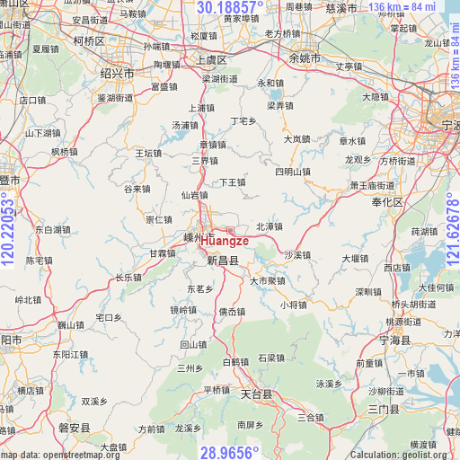
Huangze GPS coordinates[2]
29° 34' 44.184" North, 120° 55' 25.14" East
| Map corner | latitude | longitude |
|---|---|---|
| Upper-left | 30.18857°, | 120.22053° |
| Center: | 29.57894°, | 120.92365° |
| Lower-right: | 28.9656°, | 121.62678° |
| Map W x H: | 136×136 km | = 84.5×84.5mi |
| max Lat: | 53.31946° ⇑58.8% North |
| Huangze: | 29.57894° |
| min Lat: | ⇓41.2% South 18.22056° |
| min Long | Huangze | max Long |
| 75.07348° | 120.92365° | 134.28917° |
| W 87.4%⇐ | ⇒12.6% E |
Elevation
Elevation of Huangze is 36 m = 118 ft, and this is 448.8 m = 1472 ft below average elevation for this country.
| Max E: |
5622 m = 18445 ft | 75.3% |
| Avg. | 484.8 m = 1591 ft | |
| Huangze | 36 m = 118 ft | |
Min E: |
-3 m = -10 ft | 24.7% |
See also: China elevation on elevation.city.
Geographical zone
Huangze is located in North temperate zone (between Tropic of Cancer and the Arctic Circle). Distance of this Northern Tropic circle is 683 km =424.4 mi to South.| Distance of | km | miles | from Huangze |
|---|---|---|---|
| North Pole | 6718.2 | 4174.5 | to North |
| Arctic Circle | 4112.3 | 2555.3 | to North |
| Tropic Cancer | 683 | 424.4 | to South |
| Equator | 3288.9 | 2043.6 | to South |


Nearby cities:
15 places around Huangze: (largest is in red/bold)
• Beizhang
11.3 km =7 mi,  82°
82°
• Chengtan
19.4 km =12.1 mi,  221°
221°
• Chongren
21.4 km =13.3 mi,  279°
279°
• Dashiju
18.4 km =11.4 mi,  144°
144°
• Ganlin
21.3 km =13.2 mi,  252°
252°
• Meizhu
16.6 km =10.3 mi,  227°
227°
• Pukou
8.8 km =5.5 mi,  311°
311°
• Ruanzhuang
24.5 km =15.2 mi,  24°
24°
• Ru’ao
24.4 km =15.2 mi,  181°
181°
• Sanjie
21.3 km =13.2 mi,  339°
339°
• Shanhu
10.5 km =6.5 mi, 280°
• Shaxi
21 km =13 mi,  109°
109°
• Xianyan
15.1 km =9.4 mi,  315°
315°
• Xiaren
10 km =6.2 mi,  95°
95°
• Xinchang Chengguanzhen
8.5 km =5.3 mi,  195°
195°
Sources, notices
• [Note1] Compared only with cities in China existing in our database
• [Src1] Map data: © OpenStreetMap contributors (CC-BY-SA)
• [Src2] Other city data from geonames.org with taken over terms of usage.
• [Src3] Geographical zone / Annual Mean Temperature by Robert A. Rohde @ Wikipedia
