Guangling geodata
Guangling (Jiangsu) is a seat of a fourth-order administrative division; located in China in Asia/Shanghai (GMT+8) time zone. In our database, there are 1268 cities with bigger population. Compared to other cities in China, 61.8% of cities are located further ↓South; 83.4% of cities are located further ←West and 95.9% of cities have higher elevation than Guangling. Note1


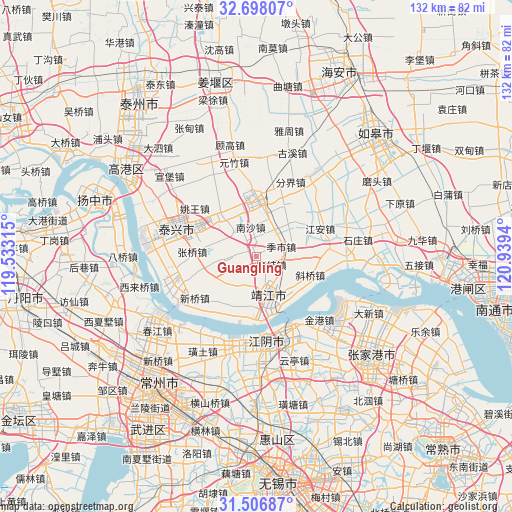
Guangling GPS coordinates[2]
32° 6' 15.876" North, 120° 14' 10.572" East
| Map corner | latitude | longitude |
|---|---|---|
| Upper-left | 32.69807°, | 119.53315° |
| Center: | 32.10441°, | 120.23627° |
| Lower-right: | 31.50687°, | 120.9394° |
| Map W x H: | 132.4×132.4 km | = 82.3×82.3mi |
| max Lat: | 53.31946° ⇑38.2% North |
| Guangling: | 32.10441° |
| min Lat: | ⇓61.8% South 18.22056° |
| min Long | Guangling | max Long |
| 75.07348° | 120.23627° | 134.28917° |
| W 83.4%⇐ | ⇒16.6% E |
Elevation
Elevation of Guangling is 6 m = 20 ft, and this is 478.8 m = 1571 ft below average elevation for this country.
| Max E: |
5622 m = 18445 ft | 95.9% |
| Avg. | 484.8 m = 1591 ft | |
| Guangling | 6 m = 20 ft | |
Min E: |
-3 m = -10 ft | 4.1% |
See also: China elevation on elevation.city.
Geographical zone
Guangling is located in North temperate zone (between Tropic of Cancer and the Arctic Circle). Distance of this Northern Tropic circle is 963.8 km =598.9 mi to South.| Distance of | km | miles | from Guangling |
|---|---|---|---|
| North Pole | 6437.4 | 4000 | to North |
| Arctic Circle | 3831.5 | 2380.8 | to North |
| Tropic Cancer | 963.8 | 598.9 | to South |
| Equator | 3569.7 | 2218.1 | to South |


Nearby cities:
15 places around Guangling: (largest is in red/bold)
• Changdai
7.8 km =4.8 mi,  193°
193°
• Dongxing
15.4 km =9.6 mi,  207°
207°
• Gushan
7.3 km =4.5 mi,  124°
124°
• Heshi
14.8 km =9.2 mi,  320°
320°
• Hongguang
13.1 km =8.1 mi,  249°
249°
• Huangqiao
15.2 km =9.4 mi,  358°
358°
• Jingjiang
10.3 km =6.4 mi,  166°
166°
• Jishi
7.4 km =4.6 mi,  62°
62°
• Nansha
7.8 km =4.8 mi,  348°
348°
• Quxia
7.5 km =4.7 mi,  266°
266°
• Shanhu
11.4 km =7.1 mi,  42°
42°
• Shengci
10.2 km =6.3 mi,  221°
221°
• Xieqiao
14.7 km =9.1 mi,  108°
108°
• Xiqiao
14.4 km =8.9 mi,  339°
339°
• Zhangqiao
16.7 km =10.4 mi, 274°
Sources, notices
• [Note1] Compared only with cities in China existing in our database
• [Src1] Map data: © OpenStreetMap contributors (CC-BY-SA)
• [Src2] Other city data from geonames.org with taken over terms of usage.
• [Src3] Geographical zone / Annual Mean Temperature by Robert A. Rohde @ Wikipedia
