Tianhe geodata
Tianhe (Hubei) is a seat of a fourth-order administrative division; located in China in Asia/Shanghai (GMT+8) time zone. In our database, there are 1268 cities with bigger population. Compared to other cities in China, 52.9% of cities are located further ↓South; 50.1% of cities are located further →East and 72.7% of cities have higher elevation than Tianhe. Note1


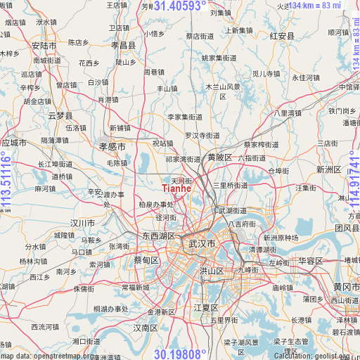
Tianhe GPS coordinates[2]
30° 48' 14.04" North, 114° 12' 51.408" East
| Map corner | latitude | longitude |
|---|---|---|
| Upper-left | 31.40593°, | 113.51116° |
| Center: | 30.8039°, | 114.21428° |
| Lower-right: | 30.19808°, | 114.91741° |
| Map W x H: | 134.3×134.3 km | = 83.5×83.5mi |
| max Lat: | 53.31946° ⇑47.1% North |
| Tianhe: | 30.8039° |
| min Lat: | ⇓52.9% South 18.22056° |
| min Long | Tianhe | max Long |
| 75.07348° | 114.21428° | 134.28917° |
| W 49.9%⇐ | ⇒50.1% E |
Elevation
Elevation of Tianhe is 43 m = 141 ft, and this is 441.8 m = 1449 ft below average elevation for this country.
| Max E: |
5622 m = 18445 ft | 72.7% |
| Avg. | 484.8 m = 1591 ft | |
| Tianhe | 43 m = 141 ft | |
Min E: |
-3 m = -10 ft | 27.3% |
See also: China elevation on elevation.city.
Geographical zone
Tianhe is located in North temperate zone (between Tropic of Cancer and the Arctic Circle). Distance of this Northern Tropic circle is 819.2 km =509 mi to South.| Distance of | km | miles | from Tianhe |
|---|---|---|---|
| North Pole | 6582 | 4089.9 | to North |
| Arctic Circle | 3976.1 | 2470.6 | to North |
| Tropic Cancer | 819.2 | 509 | to South |
| Equator | 3425.1 | 2128.3 | to South |


Nearby cities:
15 places around Tianhe: (largest is in red/bold)
• Dongshan
19.3 km =12 mi,  260°
260°
• Hengdian
7.4 km =4.6 mi,  88°
88°
• Houhu
19.2 km =11.9 mi,  146°
146°
• Huangpi
18 km =11.2 mi,  60°
60°
• Jiaomingsi
19 km =11.8 mi,  96°
96°
• Maomiaoji
12.3 km =7.6 mi,  228°
228°
• Minji
9 km =5.6 mi,  297°
297°
• Mintian
14.4 km =8.9 mi,  201°
201°
• Qianquan
16.9 km =10.5 mi, 63°
• Sancha
21.6 km =13.4 mi,  316°
316°
• Sandian
17.9 km =11.1 mi, 199°
• Shekou
16.3 km =10.1 mi,  127°
127°
• Wutongkou
21.9 km =13.6 mi,  124°
124°
• Zhanjiaji
19.9 km =12.4 mi,  138°
138°
• Zhuzhan
14.8 km =9.2 mi,  337°
337°
Sources, notices
• [Note1] Compared only with cities in China existing in our database
• [Src1] Map data: © OpenStreetMap contributors (CC-BY-SA)
• [Src2] Other city data from geonames.org with taken over terms of usage.
• [Src3] Geographical zone / Annual Mean Temperature by Robert A. Rohde @ Wikipedia
