Lijiaji geodata
Lijiaji (Hubei) is a seat of a fourth-order administrative division; located in China in Asia/Shanghai (GMT+8) time zone. In our database, there are 1268 cities with bigger population. Compared to other cities in China, 55% of cities are located further ↓South; 50% of cities are located further ←West and 65.6% of cities have higher elevation than Lijiaji. Note1


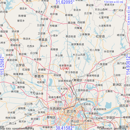
Lijiaji GPS coordinates[2]
31° 1' 13.044" North, 114° 13' 58.764" East
| Map corner | latitude | longitude |
|---|---|---|
| Upper-left | 31.62095°, | 113.52987° |
| Center: | 31.02029°, | 114.23299° |
| Lower-right: | 30.41582°, | 114.93612° |
| Map W x H: | 134×134 km | = 83.3×83.3mi |
| max Lat: | 53.31946° ⇑45% North |
| Lijiaji: | 31.02029° |
| min Lat: | ⇓55% South 18.22056° |
| min Long | Lijiaji | max Long |
| 75.07348° | 114.23299° | 134.28917° |
| W 50%⇐ | ⇒50% E |
Elevation
Elevation of Lijiaji is 70 m = 230 ft, and this is 414.8 m = 1361 ft below average elevation for this country.
| Max E: |
5622 m = 18445 ft | 65.6% |
| Avg. | 484.8 m = 1591 ft | |
| Lijiaji | 70 m = 230 ft | |
Min E: |
-3 m = -10 ft | 34.4% |
See also: China elevation on elevation.city.
Geographical zone
Lijiaji is located in North temperate zone (between Tropic of Cancer and the Arctic Circle). Distance of this Northern Tropic circle is 843.2 km =523.9 mi to South.| Distance of | km | miles | from Lijiaji |
|---|---|---|---|
| North Pole | 6557.9 | 4074.9 | to North |
| Arctic Circle | 3952 | 2455.7 | to North |
| Tropic Cancer | 843.2 | 523.9 | to South |
| Equator | 3449.1 | 2143.2 | to South |


Nearby cities:
15 places around Lijiaji: (largest is in red/bold)
• Changxuanling
13.6 km =8.5 mi,  51°
51°
• Fengshan
12.2 km =7.6 mi,  326°
326°
• Huangpi
20.5 km =12.7 mi,  137°
137°
• Minji
22.2 km =13.8 mi,  206°
206°
• Mulan
22.9 km =14.2 mi,  67°
67°
• Qianquan
21.3 km =13.2 mi, 141°
• Sancha
18.6 km =11.6 mi,  243°
243°
• Tianhe
24.1 km =15 mi,  184°
184°
• Wangjiahe
18.3 km =11.4 mi,  110°
110°
• Xihe
21.3 km =13.2 mi,  266°
266°
• Xinpu
24.4 km =15.2 mi,  260°
260°
• Yangdian
12 km =7.5 mi, 273°
• Zhouxiang
20.1 km =12.5 mi, 325°
• Zhuzhan
12.8 km =8 mi,  215°
215°
• Zougang
20.7 km =12.9 mi,  290°
290°
Sources, notices
• [Note1] Compared only with cities in China existing in our database
• [Src1] Map data: © OpenStreetMap contributors (CC-BY-SA)
• [Src2] Other city data from geonames.org with taken over terms of usage.
• [Src3] Geographical zone / Annual Mean Temperature by Robert A. Rohde @ Wikipedia
