Huangmei geodata
Huangmei (Hubei) is a seat of a third-order administrative division; located in China in Asia/Shanghai (GMT+8) time zone. With population of 77,633 people, there are 549 cities with bigger population in this country. Compared to other cities in China, 52.1% of cities are located further ↑North; 60.2% of cities are located further ←West and 71% of cities have higher elevation than Huangmei. Note1


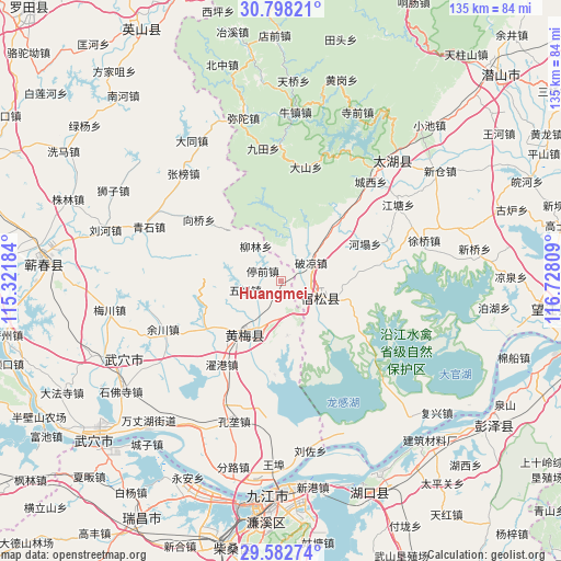
Huangmei GPS coordinates[2]
30° 11' 32.46" North, 116° 1' 29.856" East
| Map corner | latitude | longitude |
|---|---|---|
| Upper-left | 30.79821°, | 115.32184° |
| Center: | 30.19235°, | 116.02496° |
| Lower-right: | 29.58274°, | 116.72809° |
| Map W x H: | 135.1×135.1 km | = 83.9×83.9mi |
| max Lat: | 53.31946° ⇑52.1% North |
| Huangmei: | 30.19235° |
| min Lat: | ⇓47.9% South 18.22056° |
| min Long | Huangmei | max Long |
| 75.07348° | 116.02496° | 134.28917° |
| W 60.2%⇐ | ⇒39.8% E |
Elevation
Elevation of Huangmei is 48 m = 157 ft, and this is 436.8 m = 1433 ft below average elevation for this country.
| Max E: |
5622 m = 18445 ft | 71% |
| Avg. | 484.8 m = 1591 ft | |
| Huangmei | 48 m = 157 ft | |
Min E: |
-3 m = -10 ft | 29% |
See also: Huangmei elevation on elevation.city.
Geographical zone
Huangmei is located in North temperate zone (between Tropic of Cancer and the Arctic Circle). Distance of this Northern Tropic circle is 751.2 km =466.8 mi to South.| Distance of | km | miles | from Huangmei |
|---|---|---|---|
| North Pole | 6650 | 4132.1 | to North |
| Arctic Circle | 4044.1 | 2512.9 | to North |
| Tropic Cancer | 751.2 | 466.8 | to South |
| Equator | 3357.1 | 2086 | to South |


Nearby cities:
15 places around Huangmei: (largest is in red/bold)
• Dahe
21.5 km =13.4 mi,  239°
239°
• Dushan
13.2 km =8.2 mi,  173°
173°
• Fuyu
10 km =6.2 mi,  118°
118°
• Huangmei
15.1 km =9.4 mi,  213°
213°
• Kuzhu
14.5 km =9 mi, 243°
• Liulin
10.7 km =6.6 mi,  322°
322°
• Qingshi
34.6 km =21.5 mi,  292°
292°
• Shamu
10.8 km =6.7 mi, 207°
• Tingqian
5.1 km =3.2 mi,  296°
296°
• Wuzu
8.8 km =5.5 mi,  255°
255°
• Xiangqiao
30.6 km =19 mi, 301°
• Xiaxin
22.6 km =14 mi,  184°
184°
• Yuchuan
30.7 km =19.1 mi,  247°
247°
• Zhanghekou
34.4 km =21.4 mi,  230°
230°
• Zhuogang
24.6 km =15.3 mi,  215°
215°
Sources, notices
• [Note1] Compared only with cities in China existing in our database
• [Src1] Map data: © OpenStreetMap contributors (CC-BY-SA)
• [Src2] Other city data from geonames.org with taken over terms of usage.
• [Src3] Geographical zone / Annual Mean Temperature by Robert A. Rohde @ Wikipedia
