Dushan geodata
Dushan (Hubei) is a seat of a fourth-order administrative division; located in China in Asia/Shanghai (GMT+8) time zone. In our database, there are 1268 cities with bigger population. Compared to other cities in China, 53.2% of cities are located further ↑North; 60.3% of cities are located further ←West and 80.8% of cities have higher elevation than Dushan. Note1


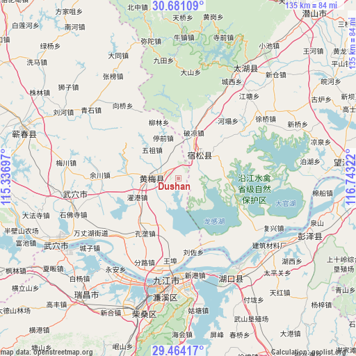
Dushan GPS coordinates[2]
30° 4' 28.2" North, 116° 2' 24.324" East
| Map corner | latitude | longitude |
|---|---|---|
| Upper-left | 30.68109°, | 115.33697° |
| Center: | 30.0745°, | 116.04009° |
| Lower-right: | 29.46417°, | 116.74322° |
| Map W x H: | 135.3×135.3 km | = 84.1×84.1mi |
| max Lat: | 53.31946° ⇑53.2% North |
| Dushan: | 30.0745° |
| min Lat: | ⇓46.8% South 18.22056° |
| min Long | Dushan | max Long |
| 75.07348° | 116.04009° | 134.28917° |
| W 60.3%⇐ | ⇒39.7% E |
Elevation
Elevation of Dushan is 25 m = 82 ft, and this is 459.8 m = 1509 ft below average elevation for this country.
| Max E: |
5622 m = 18445 ft | 80.8% |
| Avg. | 484.8 m = 1591 ft | |
| Dushan | 25 m = 82 ft | |
Min E: |
-3 m = -10 ft | 19.2% |
See also: China elevation on elevation.city.
Geographical zone
Dushan is located in North temperate zone (between Tropic of Cancer and the Arctic Circle). Distance of this Northern Tropic circle is 738.1 km =458.6 mi to South.| Distance of | km | miles | from Dushan |
|---|---|---|---|
| North Pole | 6663.1 | 4140.3 | to North |
| Arctic Circle | 4057.2 | 2521 | to North |
| Tropic Cancer | 738.1 | 458.6 | to South |
| Equator | 3344 | 2077.9 | to South |


Nearby cities:
15 places around Dushan: (largest is in red/bold)
• Dahe
20.2 km =12.6 mi,  276°
276°
• Fuyu
11.2 km =7 mi,  41°
41°
• Huangmei
9.8 km =6.1 mi,  272°
272°
• Huangmei
13.2 km =8.2 mi,  353°
353°
• Konglong
24.7 km =15.3 mi,  212°
212°
• Kuzhu
15.8 km =9.8 mi,  294°
294°
• Liulin
23.1 km =14.4 mi,  339°
339°
• Liuzuo
28.5 km =17.7 mi,  168°
168°
• Shamu
7.4 km =4.6 mi,  298°
298°
• Tingqian
16.5 km =10.3 mi, 338°
• Wuzu
14.8 km =9.2 mi,  317°
317°
• Xiaxin
10 km =6.2 mi,  198°
198°
• Yuchuan
30 km =18.6 mi, 272°
• Zhanghekou
29.4 km =18.3 mi,  252°
252°
• Zhuogang
17.2 km =10.7 mi, 246°
Sources, notices
• [Note1] Compared only with cities in China existing in our database
• [Src1] Map data: © OpenStreetMap contributors (CC-BY-SA)
• [Src2] Other city data from geonames.org with taken over terms of usage.
• [Src3] Geographical zone / Annual Mean Temperature by Robert A. Rohde @ Wikipedia
