Xiaxin geodata
Xiaxin (Hubei) is a seat of a fourth-order administrative division; located in China in Asia/Shanghai (GMT+8) time zone. In our database, there are 1268 cities with bigger population. Compared to other cities in China, 54.1% of cities are located further ↑North; 60.1% of cities are located further ←West and 81.6% of cities have higher elevation than Xiaxin. Note1


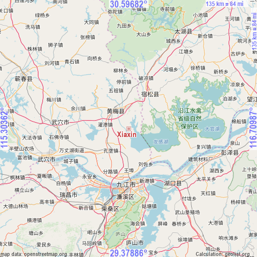
Xiaxin GPS coordinates[2]
29° 59' 22.956" North, 116° 0' 24.264" East
| Map corner | latitude | longitude |
|---|---|---|
| Upper-left | 30.59682°, | 115.30362° |
| Center: | 29.98971°, | 116.00674° |
| Lower-right: | 29.37886°, | 116.70987° |
| Map W x H: | 135.4×135.4 km | = 84.1×84.1mi |
| max Lat: | 53.31946° ⇑54.1% North |
| Xiaxin: | 29.98971° |
| min Lat: | ⇓45.9% South 18.22056° |
| min Long | Xiaxin | max Long |
| 75.07348° | 116.00674° | 134.28917° |
| W 60.1%⇐ | ⇒39.9% E |
Elevation
Elevation of Xiaxin is 23 m = 75 ft, and this is 461.8 m = 1515 ft below average elevation for this country.
| Max E: |
5622 m = 18445 ft | 81.6% |
| Avg. | 484.8 m = 1591 ft | |
| Xiaxin | 23 m = 75 ft | |
Min E: |
-3 m = -10 ft | 18.4% |
See also: China elevation on elevation.city.
Geographical zone
Xiaxin is located in North temperate zone (between Tropic of Cancer and the Arctic Circle). Distance of this Northern Tropic circle is 728.6 km =452.7 mi to South.| Distance of | km | miles | from Xiaxin |
|---|---|---|---|
| North Pole | 6672.5 | 4146.1 | to North |
| Arctic Circle | 4066.6 | 2526.9 | to North |
| Tropic Cancer | 728.6 | 452.7 | to South |
| Equator | 3334.5 | 2072 | to South |


Nearby cities:
15 places around Xiaxin: (largest is in red/bold)
• Caishan
24.2 km =15 mi,  240°
240°
• Dahe
20.5 km =12.7 mi,  304°
304°
• Dushan
10 km =6.2 mi,  18°
18°
• Fenlu
24.5 km =15.2 mi,  204°
204°
• Fuyu
20.7 km =12.9 mi,  30°
30°
• Huangmei
11.9 km =7.4 mi,  326°
326°
• Huangmei
22.6 km =14 mi,  4°
4°
• Jiangzhou
25 km =15.5 mi,  154°
154°
• Konglong
15.2 km =9.4 mi,  221°
221°
• Kuzhu
19.5 km =12.1 mi,  324°
324°
• Liuzuo
20.5 km =12.7 mi, 154°
• Shamu
13.4 km =8.3 mi,  345°
345°
• Wuzu
21.5 km =13.4 mi,  341°
341°
• Zhanghekou
24.8 km =15.4 mi,  271°
271°
• Zhuogang
12.9 km =8 mi,  281°
281°
Sources, notices
• [Note1] Compared only with cities in China existing in our database
• [Src1] Map data: © OpenStreetMap contributors (CC-BY-SA)
• [Src2] Other city data from geonames.org with taken over terms of usage.
• [Src3] Geographical zone / Annual Mean Temperature by Robert A. Rohde @ Wikipedia
