Qingshi geodata
Qingshi (Hubei) is a seat of a fourth-order administrative division; located in China in Asia/Shanghai (GMT+8) time zone. In our database, there are 1268 cities with bigger population. Compared to other cities in China, 51.1% of cities are located further ↑North; 58.1% of cities are located further ←West and 68.4% of cities have higher elevation than Qingshi. Note1


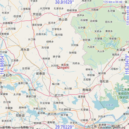
Qingshi GPS coordinates[2]
30° 18' 40.212" North, 115° 41' 29.976" East
| Map corner | latitude | longitude |
|---|---|---|
| Upper-left | 30.91629°, | 114.98854° |
| Center: | 30.31117°, | 115.69166° |
| Lower-right: | 29.70229°, | 116.39479° |
| Map W x H: | 135×135 km | = 83.9×83.9mi |
| max Lat: | 53.31946° ⇑51.1% North |
| Qingshi: | 30.31117° |
| min Lat: | ⇓48.9% South 18.22056° |
| min Long | Qingshi | max Long |
| 75.07348° | 115.69166° | 134.28917° |
| W 58.1%⇐ | ⇒41.9% E |
Elevation
Elevation of Qingshi is 58 m = 190 ft, and this is 426.8 m = 1400 ft below average elevation for this country.
| Max E: |
5622 m = 18445 ft | 68.4% |
| Avg. | 484.8 m = 1591 ft | |
| Qingshi | 58 m = 190 ft | |
Min E: |
-3 m = -10 ft | 31.6% |
See also: China elevation on elevation.city.
Geographical zone
Qingshi is located in North temperate zone (between Tropic of Cancer and the Arctic Circle). Distance of this Northern Tropic circle is 764.4 km =475 mi to South.| Distance of | km | miles | from Qingshi |
|---|---|---|---|
| North Pole | 6636.8 | 4123.9 | to North |
| Arctic Circle | 4030.9 | 2504.7 | to North |
| Tropic Cancer | 764.4 | 475 | to South |
| Equator | 3370.3 | 2094.2 | to South |


Nearby cities:
15 places around Qingshi: (largest is in red/bold)
• Caohe
26.4 km =16.4 mi,  249°
249°
• Dahe
27.6 km =17.1 mi,  150°
150°
• Datong
23.1 km =14.4 mi,  26°
26°
• Kuzhu
27.5 km =17.1 mi,  136°
136°
• Liuhe
11 km =6.8 mi,  263°
263°
• Liulin
25.9 km =16.1 mi,  100°
100°
• Meichuan
22.2 km =13.8 mi,  204°
204°
• Shizi
12 km =7.5 mi,  315°
315°
• Tanlin
27.8 km =17.3 mi, 32°
• Xiangqiao
6.4 km =4 mi,  65°
65°
• Xima
27.4 km =17 mi,  310°
310°
• Yuchuan
25.1 km =15.6 mi,  171°
171°
• Zhangbang
15.3 km =9.5 mi, 34°
• Zhulin
20.3 km =12.6 mi,  288°
288°
• Zoumaling
27.7 km =17.2 mi, 246°
Sources, notices
• [Note1] Compared only with cities in China existing in our database
• [Src1] Map data: © OpenStreetMap contributors (CC-BY-SA)
• [Src2] Other city data from geonames.org with taken over terms of usage.
• [Src3] Geographical zone / Annual Mean Temperature by Robert A. Rohde @ Wikipedia
