Huangcun geodata
Huangcun (Anhui) is a seat of a fourth-order administrative division; located in China in Asia/Shanghai (GMT+8) time zone. In our database, there are 1268 cities with bigger population. Compared to other cities in China, 51.2% of cities are located further ↓South; 72.1% of cities are located further ←West and 70% of cities have higher elevation than Huangcun. Note1


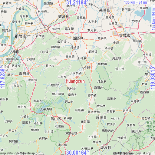
Huangcun GPS coordinates[2]
30° 36' 31.248" North, 118° 19' 37.272" East
| Map corner | latitude | longitude |
|---|---|---|
| Upper-left | 31.21194°, | 117.6239° |
| Center: | 30.60868°, | 118.32702° |
| Lower-right: | 30.00164°, | 119.03015° |
| Map W x H: | 134.6×134.6 km | = 83.6×83.6mi |
| max Lat: | 53.31946° ⇑48.8% North |
| Huangcun: | 30.60868° |
| min Lat: | ⇓51.2% South 18.22056° |
| min Long | Huangcun | max Long |
| 75.07348° | 118.32702° | 134.28917° |
| W 72.1%⇐ | ⇒27.9% E |
Elevation
Elevation of Huangcun is 52 m = 171 ft, and this is 432.8 m = 1420 ft below average elevation for this country.
| Max E: |
5622 m = 18445 ft | 70% |
| Avg. | 484.8 m = 1591 ft | |
| Huangcun | 52 m = 171 ft | |
Min E: |
-3 m = -10 ft | 30% |
See also: China elevation on elevation.city.
Geographical zone
Huangcun is located in North temperate zone (between Tropic of Cancer and the Arctic Circle). Distance of this Northern Tropic circle is 797.4 km =495.5 mi to South.| Distance of | km | miles | from Huangcun |
|---|---|---|---|
| North Pole | 6603.7 | 4103.3 | to North |
| Arctic Circle | 3997.8 | 2484.1 | to North |
| Tropic Cancer | 797.4 | 495.5 | to South |
| Equator | 3403.4 | 2114.8 | to South |


Nearby cities:
15 places around Huangcun: (largest is in red/bold)
• Anwu
7.9 km =4.9 mi,  253°
253°
• Beigong
14.6 km =9.1 mi,  303°
303°
• Changqiao
18.4 km =11.4 mi,  24°
24°
• Dingjiaqiao
4.5 km =2.8 mi,  336°
336°
• Gufeng
17.4 km =10.8 mi,  11°
11°
• Jingchuan
11.6 km =7.2 mi,  39°
39°
• Langqiao
18.9 km =11.7 mi,  140°
140°
• Maolin
13.4 km =8.3 mi,  214°
214°
• Sanli
19.8 km =12.3 mi, 339°
• Taiyuan
13.4 km =8.3 mi,  31°
31°
• Xiyang
19.8 km =12.3 mi,  115°
115°
• Yangong
12.7 km =7.9 mi,  68°
68°
• Yunling
11 km =6.8 mi, 296°
• Zhangdu
9.6 km =6 mi,  261°
261°
• Zhongcun
13.8 km =8.6 mi,  273°
273°
Sources, notices
• [Note1] Compared only with cities in China existing in our database
• [Src1] Map data: © OpenStreetMap contributors (CC-BY-SA)
• [Src2] Other city data from geonames.org with taken over terms of usage.
• [Src3] Geographical zone / Annual Mean Temperature by Robert A. Rohde @ Wikipedia
