Huangbei geodata
Huangbei (Jiangxi) is a seat of a fourth-order administrative division; located in China in Asia/Shanghai (GMT+8) time zone. In our database, there are 1268 cities with bigger population. Compared to other cities in China, 77.4% of cities are located further ↑North; 60.8% of cities are located further ←West and 55.5% of cities have higher elevation than Huangbei. Note1


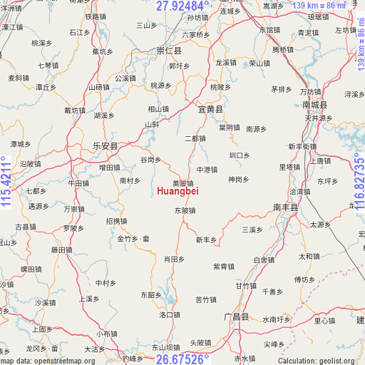
Huangbei GPS coordinates[2]
27° 18' 6.516" North, 116° 7' 27.192" East
| Map corner | latitude | longitude |
|---|---|---|
| Upper-left | 27.92484°, | 115.4211° |
| Center: | 27.30181°, | 116.12422° |
| Lower-right: | 26.67526°, | 116.82735° |
| Map W x H: | 138.9×138.9 km | = 86.3×86.3mi |
| max Lat: | 53.31946° ⇑77.4% North |
| Huangbei: | 27.30181° |
| min Lat: | ⇓22.6% South 18.22056° |
| min Long | Huangbei | max Long |
| 75.07348° | 116.12422° | 134.28917° |
| W 60.8%⇐ | ⇒39.2% E |
Elevation
Elevation of Huangbei is 128 m = 420 ft, and this is 356.8 m = 1171 ft below average elevation for this country.
| Max E: |
5622 m = 18445 ft | 55.5% |
| Avg. | 484.8 m = 1591 ft | |
| Huangbei | 128 m = 420 ft | |
Min E: |
-3 m = -10 ft | 44.5% |
See also: China elevation on elevation.city.
Geographical zone
Huangbei is located in North temperate zone (between Tropic of Cancer and the Arctic Circle). Distance of this Northern Tropic circle is 429.8 km =267.1 mi to South.| Distance of | km | miles | from Huangbei |
|---|---|---|---|
| North Pole | 6971.4 | 4331.8 | to North |
| Arctic Circle | 4365.5 | 2712.6 | to North |
| Tropic Cancer | 429.8 | 267.1 | to South |
| Equator | 3035.7 | 1886.3 | to South |


Nearby cities:
15 places around Huangbei: (largest is in red/bold)
• Aoxi
31.6 km =19.6 mi,  295°
295°
• Dongbei
10.3 km =6.4 mi,  176°
176°
• Erdu
17.8 km =11.1 mi,  15°
15°
• Fenggang
28.5 km =17.7 mi, 18°
• Gugang
15.2 km =9.4 mi,  306°
306°
• Nancun
20.2 km =12.6 mi,  272°
272°
• Pingxi
28.2 km =17.5 mi,  222°
222°
• Tangyin
27.8 km =17.3 mi,  39°
39°
• Wangxian
25.4 km =15.8 mi,  258°
258°
• Xiangshan
29.9 km =18.6 mi,  341°
341°
• Xiaotian
29.1 km =18.1 mi,  186°
186°
• Xinfeng
23.2 km =14.4 mi,  157°
157°
• Zengtian
28.8 km =17.9 mi,  282°
282°
• Zhaoxie
29.2 km =18.1 mi,  239°
239°
• Zhenkou
24.1 km =15 mi,  63°
63°
Sources, notices
• [Note1] Compared only with cities in China existing in our database
• [Src1] Map data: © OpenStreetMap contributors (CC-BY-SA)
• [Src2] Other city data from geonames.org with taken over terms of usage.
• [Src3] Geographical zone / Annual Mean Temperature by Robert A. Rohde @ Wikipedia
