Xinfeng geodata
Xinfeng (Jiangxi) is a seat of a fourth-order administrative division; located in China in Asia/Shanghai (GMT+8) time zone. In our database, there are 1268 cities with bigger population. Compared to other cities in China, 78.2% of cities are located further ↑North; 61.2% of cities are located further ←West and 62.8% of cities have lower elevation than Xinfeng. Note1


Xinfeng GPS coordinates[2]
27° 6' 32.04" North, 116° 12' 47.412" East
| Map corner | latitude | longitude |
|---|---|---|
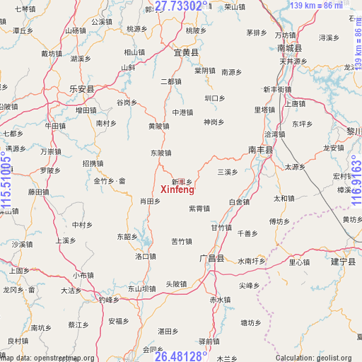
| Upper-left | 27.73302°, | 115.51005° |
| Center: | 27.1089°, | 116.21317° |
| Lower-right: | 26.48128°, | 116.9163° |
| Map W x H: | 139.2×139.2 km | = 86.5×86.5mi |
| max Lat: | 53.31946° ⇑78.2% North |
| Xinfeng: | 27.1089° |
| min Lat: | ⇓21.8% South 18.22056° |
| min Long | Xinfeng | max Long |
| 75.07348° | 116.21317° | 134.28917° |
| W 61.2%⇐ | ⇒38.8% E |
Elevation
Elevation of Xinfeng is 293 m = 961 ft, and this is 191.8 m = 629 ft below average elevation for this country.
| Max E: |
5622 m = 18445 ft | 37.2% |
| Avg. | 484.8 m = 1591 ft | |
| Xinfeng | 293 m = 961 ft | |
Min E: |
-3 m = -10 ft | 62.8% |
See also: China elevation on elevation.city.
Geographical zone
Xinfeng is located in North temperate zone (between Tropic of Cancer and the Arctic Circle). Distance of this Northern Tropic circle is 408.3 km =253.7 mi to South.| Distance of | km | miles | from Xinfeng |
|---|---|---|---|
| North Pole | 6992.8 | 4345.1 | to North |
| Arctic Circle | 4386.9 | 2725.9 | to North |
| Tropic Cancer | 408.3 | 253.7 | to South |
| Equator | 3014.2 | 1872.9 | to South |


Nearby cities:
15 places around Xinfeng: (largest is in red/bold)
• Baishe
23.4 km =14.5 mi,  108°
108°
• Dongbei
13.8 km =8.6 mi,  324°
324°
• Dongshao
28 km =17.4 mi,  227°
227°
• Huangbei
23.2 km =14.4 mi,  337°
337°
• Jinzhu
33.3 km =20.7 mi,  253°
253°
• Kuzhu
22.9 km =14.2 mi,  180°
180°
• Luokou
31.8 km =19.8 mi,  206°
206°
• Pingxi
27.9 km =17.3 mi,  271°
271°
• Qianshan
32.2 km =20 mi,  127°
127°
• Qincheng
33.4 km =20.8 mi,  69°
69°
• Sanxi
18.2 km =11.3 mi,  77°
77°
• Shishan
30.3 km =18.8 mi, 67°
• Xiaotian
14.1 km =8.8 mi,  238°
238°
• Xujiang
31.8 km =19.8 mi,  160°
160°
• Zixiao
12.3 km =7.6 mi,  145°
145°
Sources, notices
• [Note1] Compared only with cities in China existing in our database
• [Src1] Map data: © OpenStreetMap contributors (CC-BY-SA)
• [Src2] Other city data from geonames.org with taken over terms of usage.
• [Src3] Geographical zone / Annual Mean Temperature by Robert A. Rohde @ Wikipedia
