Honglai geodata
Honglai (Fujian) is a seat of a fourth-order administrative division; located in China in Asia/Shanghai (GMT+8) time zone. In our database, there are 1268 cities with bigger population. Compared to other cities in China, 86% of cities are located further ↑North; 73.3% of cities are located further ←West and 78.3% of cities have higher elevation than Honglai. Note1


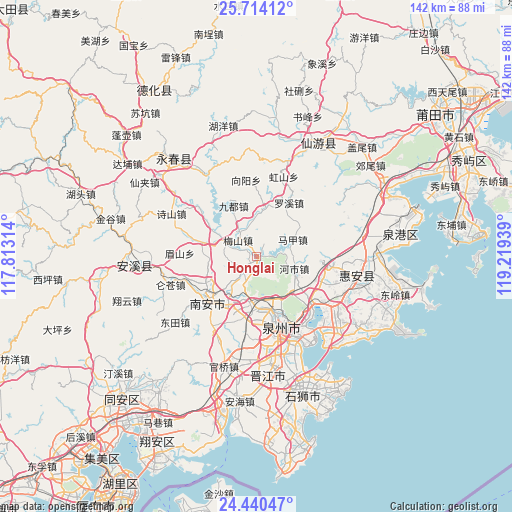
Honglai GPS coordinates[2]
25° 4' 44.22" North, 118° 30' 58.536" East
| Map corner | latitude | longitude |
|---|---|---|
| Upper-left | 25.71412°, | 117.81314° |
| Center: | 25.07895°, | 118.51626° |
| Lower-right: | 24.44047°, | 119.21939° |
| Map W x H: | 141.6×141.6 km | = 88×88mi |
| max Lat: | 53.31946° ⇑86% North |
| Honglai: | 25.07895° |
| min Lat: | ⇓14% South 18.22056° |
| min Long | Honglai | max Long |
| 75.07348° | 118.51626° | 134.28917° |
| W 73.3%⇐ | ⇒26.7% E |
Elevation
Elevation of Honglai is 30 m = 98 ft, and this is 454.8 m = 1492 ft below average elevation for this country.
| Max E: |
5622 m = 18445 ft | 78.3% |
| Avg. | 484.8 m = 1591 ft | |
| Honglai | 30 m = 98 ft | |
Min E: |
-3 m = -10 ft | 21.7% |
See also: China elevation on elevation.city.
Geographical zone
Honglai is located in North temperate zone (between Tropic of Cancer and the Arctic Circle). Distance of this Northern Tropic circle is 182.6 km =113.5 mi to South.| Distance of | km | miles | from Honglai |
|---|---|---|---|
| North Pole | 7218.5 | 4485.4 | to North |
| Arctic Circle | 4612.7 | 2866.2 | to North |
| Tropic Cancer | 182.6 | 113.5 | to South |
| Equator | 2788.5 | 1732.7 | to South |


Nearby cities:
15 places around Honglai: (largest is in red/bold)
• Fashi
24.3 km =15.1 mi,  154°
154°
• Fengzhou
13.6 km =8.5 mi,  172°
172°
• Hongshan
23.4 km =14.5 mi,  18°
18°
• Jintao
17.1 km =10.6 mi,  285°
285°
• Jiudu
15.3 km =9.5 mi,  335°
335°
• Kangmei
6.3 km =3.9 mi,  226°
226°
• Luodong
9.2 km =5.7 mi,  345°
345°
• Luoyang
21.4 km =13.3 mi,  128°
128°
• Matou
19.9 km =12.4 mi,  309°
309°
• Meishan
6.8 km =4.2 mi, 311°
• Meishan
21.5 km =13.4 mi,  271°
271°
• Quanzhou
19.6 km =12.2 mi,  159°
159°
• Shengxin
14.3 km =8.9 mi,  250°
250°
• Xiamei
16 km =9.9 mi,  193°
193°
• Ximei
16.6 km =10.3 mi, 232°
Sources, notices
• [Note1] Compared only with cities in China existing in our database
• [Src1] Map data: © OpenStreetMap contributors (CC-BY-SA)
• [Src2] Other city data from geonames.org with taken over terms of usage.
• [Src3] Geographical zone / Annual Mean Temperature by Robert A. Rohde @ Wikipedia
