Fashi geodata
Fashi (Fujian) is a seat of a fourth-order administrative division; located in China in Asia/Shanghai (GMT+8) time zone. In our database, there are 1268 cities with bigger population. Compared to other cities in China, 86.9% of cities are located further ↑North; 73.9% of cities are located further ←West and 86.2% of cities have higher elevation than Fashi. Note1


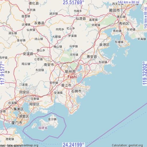
Fashi GPS coordinates[2]
24° 52' 53.364" North, 118° 37' 8.004" East
| Map corner | latitude | longitude |
|---|---|---|
| Upper-left | 25.51769°, | 117.91577° |
| Center: | 24.88149°, | 118.61889° |
| Lower-right: | 24.24199°, | 119.32202° |
| Map W x H: | 141.8×141.8 km | = 88.1×88.1mi |
| max Lat: | 53.31946° ⇑86.9% North |
| Fashi: | 24.88149° |
| min Lat: | ⇓13.1% South 18.22056° |
| min Long | Fashi | max Long |
| 75.07348° | 118.61889° | 134.28917° |
| W 73.9%⇐ | ⇒26.1% E |
Elevation
Elevation of Fashi is 14 m = 46 ft, and this is 470.8 m = 1545 ft below average elevation for this country.
| Max E: |
5622 m = 18445 ft | 86.2% |
| Avg. | 484.8 m = 1591 ft | |
| Fashi | 14 m = 46 ft | |
Min E: |
-3 m = -10 ft | 13.8% |
See also: China elevation on elevation.city.
Geographical zone
Fashi is located in North temperate zone (between Tropic of Cancer and the Arctic Circle). Distance of this Northern Tropic circle is 160.6 km =99.8 mi to South.| Distance of | km | miles | from Fashi |
|---|---|---|---|
| North Pole | 7240.5 | 4499 | to North |
| Arctic Circle | 4634.6 | 2879.8 | to North |
| Tropic Cancer | 160.6 | 99.8 | to South |
| Equator | 2766.6 | 1719.1 | to South |


Nearby cities:
15 places around Fashi: (largest is in red/bold)
• Baiqi
9.1 km =5.7 mi,  89°
89°
• Chendai
6.9 km =4.3 mi,  196°
196°
• Chidian
5.2 km =3.2 mi,  243°
243°
• Cizao
14.8 km =9.2 mi, 242°
• Dongyuan
14 km =8.7 mi,  73°
73°
• Fengzhou
12.1 km =7.5 mi,  314°
314°
• Jinjiang
8.2 km =5.1 mi,  213°
213°
• Kangmei
23.1 km =14.4 mi,  319°
319°
• Luoyang
10.8 km =6.7 mi,  36°
36°
• Maping
22.6 km =14 mi, 197°
• Neikeng
19.2 km =11.9 mi, 236°
• Quanzhou
4.9 km =3 mi, 317°
• Shishi
15.7 km =9.8 mi,  176°
176°
• Xiamei
15.5 km =9.6 mi,  294°
294°
• Xibin
9.2 km =5.7 mi, 179°
Sources, notices
• [Note1] Compared only with cities in China existing in our database
• [Src1] Map data: © OpenStreetMap contributors (CC-BY-SA)
• [Src2] Other city data from geonames.org with taken over terms of usage.
• [Src3] Geographical zone / Annual Mean Temperature by Robert A. Rohde @ Wikipedia
