Quanzhou geodata
Quanzhou (Fujian) is a seat of a second-order administrative division; located in China in Asia/Shanghai (GMT+8) time zone. With population of 184,143 people, there are 244 cities with bigger population in this country. Compared to other cities in China, 86.8% of cities are located further ↑North; 73.8% of cities are located further ←West and 86.2% of cities have higher elevation than Quanzhou. Note1


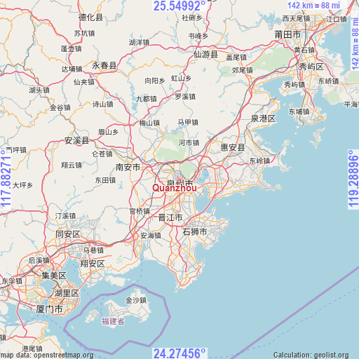
Quanzhou GPS coordinates[2]
24° 54' 50.004" North, 118° 35' 8.988" East
| Map corner | latitude | longitude |
|---|---|---|
| Upper-left | 25.54992°, | 117.88271° |
| Center: | 24.91389°, | 118.58583° |
| Lower-right: | 24.27456°, | 119.28896° |
| Map W x H: | 141.8×141.8 km | = 88.1×88.1mi |
| max Lat: | 53.31946° ⇑86.8% North |
| Quanzhou: | 24.91389° |
| min Lat: | ⇓13.2% South 18.22056° |
| min Long | Quanzhou | max Long |
| 75.07348° | 118.58583° | 134.28917° |
| W 73.8%⇐ | ⇒26.2% E |
Elevation
Elevation of Quanzhou is 14 m = 46 ft, and this is 470.8 m = 1545 ft below average elevation for this country.
| Max E: |
5622 m = 18445 ft | 86.2% |
| Avg. | 484.8 m = 1591 ft | |
| Quanzhou | 14 m = 46 ft | |
Min E: |
-3 m = -10 ft | 13.8% |
See also: Quanzhou elevation on elevation.city.
Geographical zone
Quanzhou is located in North temperate zone (between Tropic of Cancer and the Arctic Circle). Distance of this Northern Tropic circle is 164.2 km =102 mi to South.| Distance of | km | miles | from Quanzhou |
|---|---|---|---|
| North Pole | 7236.9 | 4496.8 | to North |
| Arctic Circle | 4631 | 2877.6 | to North |
| Tropic Cancer | 164.2 | 102 | to South |
| Equator | 2770.2 | 1721.3 | to South |


Nearby cities:
15 places around Quanzhou: (largest is in red/bold)
• Baiqi
12.9 km =8 mi,  105°
105°
• Chendai
10.3 km =6.4 mi,  172°
172°
• Chidian
6 km =3.7 mi,  192°
192°
• Cizao
14.3 km =8.9 mi,  223°
223°
• Dongyuan
16.8 km =10.4 mi,  88°
88°
• Fashi
4.9 km =3 mi,  137°
137°
• Fengzhou
7.2 km =4.5 mi,  312°
312°
• Honglai
19.6 km =12.2 mi,  339°
339°
• Jinjiang
10.5 km =6.5 mi, 186°
• Kangmei
18.2 km =11.3 mi,  320°
320°
• Luoyang
11 km =6.8 mi,  62°
62°
• Neikeng
19.1 km =11.9 mi, 221°
• Shishi
19.8 km =12.3 mi, 167°
• Xiamei
11.2 km =7 mi,  284°
284°
• Xibin
13.2 km =8.2 mi,  164°
164°
Sources, notices
• [Note1] Compared only with cities in China existing in our database
• [Src1] Map data: © OpenStreetMap contributors (CC-BY-SA)
• [Src2] Other city data from geonames.org with taken over terms of usage.
• [Src3] Geographical zone / Annual Mean Temperature by Robert A. Rohde @ Wikipedia
