Huangwu geodata
Huangwu (Zhejiang) is a seat of a fourth-order administrative division; located in China in Asia/Shanghai (GMT+8) time zone. In our database, there are 1268 cities with bigger population. Compared to other cities in China, 64.5% of cities are located further ↑North; 88.5% of cities are located further ←West and 61.5% of cities have higher elevation than Huangwu. Note1


Huangwu GPS coordinates[2]
29° 5' 4.344" North, 121° 9' 57.96" East
| Map corner | latitude | longitude |
|---|---|---|
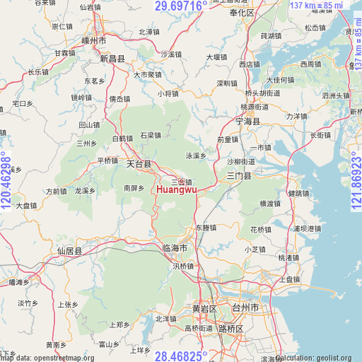
| Upper-left | 29.69716°, | 120.46298° |
| Center: | 29.08454°, | 121.1661° |
| Lower-right: | 28.46825°, | 121.86923° |
| Map W x H: | 136.6×136.6 km | = 84.9×84.9mi |
| max Lat: | 53.31946° ⇑64.5% North |
| Huangwu: | 29.08454° |
| min Lat: | ⇓35.5% South 18.22056° |
| min Long | Huangwu | max Long |
| 75.07348° | 121.1661° | 134.28917° |
| W 88.5%⇐ | ⇒11.5% E |
Elevation
Elevation of Huangwu is 90 m = 295 ft, and this is 394.8 m = 1295 ft below average elevation for this country.
| Max E: |
5622 m = 18445 ft | 61.5% |
| Avg. | 484.8 m = 1591 ft | |
| Huangwu | 90 m = 295 ft | |
Min E: |
-3 m = -10 ft | 38.5% |
See also: China elevation on elevation.city.
Geographical zone
Huangwu is located in North temperate zone (between Tropic of Cancer and the Arctic Circle). Distance of this Northern Tropic circle is 628 km =390.2 mi to South.| Distance of | km | miles | from Huangwu |
|---|---|---|---|
| North Pole | 6773.2 | 4208.7 | to North |
| Arctic Circle | 4167.3 | 2589.4 | to North |
| Tropic Cancer | 628 | 390.2 | to South |
| Equator | 3233.9 | 2009.5 | to South |


Nearby cities:
15 places around Huangwu: (largest is in red/bold)
• Chalu
19.6 km =12.2 mi,  47°
47°
• Dacun
4.5 km =2.8 mi,  136°
136°
• Datian
19.9 km =12.4 mi,  171°
171°
• Dongcheng
20 km =12.4 mi,  149°
149°
• Feikeng
23.5 km =14.6 mi,  16°
16°
• Haiyou
20.6 km =12.8 mi,  77°
77°
• Hetou
12 km =7.5 mi,  215°
215°
• Huixi
14.5 km =9 mi,  162°
162°
• Sangzhou
16.7 km =10.4 mi,  60°
60°
• Shiliang
21.1 km =13.1 mi,  325°
325°
• Tantou
5.5 km =3.4 mi,  303°
303°
• Tiantai Chengguanzhen
14.5 km =9 mi,  293°
293°
• Tingpang
17.5 km =10.9 mi,  106°
106°
• Yongfeng
23 km =14.3 mi,  204°
204°
• Zhu’ao
11.8 km =7.3 mi,  98°
98°
Sources, notices
• [Note1] Compared only with cities in China existing in our database
• [Src1] Map data: © OpenStreetMap contributors (CC-BY-SA)
• [Src2] Other city data from geonames.org with taken over terms of usage.
• [Src3] Geographical zone / Annual Mean Temperature by Robert A. Rohde @ Wikipedia
