Heicheng geodata
Heicheng (Ningxia Hui Autonomous Region) is a seat of a fourth-order administrative division; located in China in Asia/Shanghai (GMT+8) time zone. In our database, there are 1268 cities with bigger population. Compared to other cities in China, 77.9% of cities are located further ↓South; 86.5% of cities are located further →East and 91.5% of cities have lower elevation than Heicheng. Note1


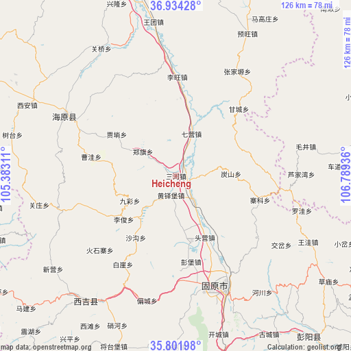
Heicheng GPS coordinates[2]
36° 22' 12.684" North, 106° 5' 10.428" East
| Map corner | latitude | longitude |
|---|---|---|
| Upper-left | 36.93428°, | 105.38311° |
| Center: | 36.37019°, | 106.08623° |
| Lower-right: | 35.80198°, | 106.78936° |
| Map W x H: | 125.9×125.9 km | = 78.2×78.2mi |
| max Lat: | 53.31946° ⇑22.1% North |
| Heicheng: | 36.37019° |
| min Lat: | ⇓77.9% South 18.22056° |
| min Long | Heicheng | max Long |
| 75.07348° | 106.08623° | 134.28917° |
| W 13.5%⇐ | ⇒86.5% E |
Elevation
Elevation of Heicheng is 1524 m = 5000 ft, and this is 1039.2 m = 3409 ft above average elevation for this country.
| Max E: |
5622 m = 18445 ft | 8.5% |
| Heicheng | 1524 m 5000 ft | |
| Avg. | 484.8 m = 1591 ft | |
Min E: |
-3 m = -10 ft | 91.5% |
See also: China elevation on elevation.city.
Geographical zone
Heicheng is located in North temperate zone (between Tropic of Cancer and the Arctic Circle). Distance of this Northern Tropic circle is 1438.1 km =893.6 mi to South.| Distance of | km | miles | from Heicheng |
|---|---|---|---|
| North Pole | 5963.1 | 3705.3 | to North |
| Arctic Circle | 3357.2 | 2086.1 | to North |
| Tropic Cancer | 1438.1 | 893.6 | to South |
| Equator | 4044 | 2512.8 | to South |


Nearby cities:
15 places around Heicheng: (largest is in red/bold)
• Gaotai
27.5 km =17.1 mi,  71°
71°
• Gongbailiang
19.9 km =12.4 mi,  88°
88°
• Heiquan
30.8 km =19.1 mi,  163°
163°
• Huangduobu
7.3 km =4.5 mi,  194°
194°
• Liwang
33.1 km =20.6 mi,  2°
2°
• Luochuan
28 km =17.4 mi,  344°
344°
• Pengbao
31.4 km =19.5 mi,  170°
170°
• Qiying
15.8 km =9.8 mi,  20°
20°
• Sanying
11.6 km =7.2 mi,  147°
147°
• Tanshan
19.6 km =12.2 mi, 87°
• Touying
25.7 km =16 mi, 152°
• Xinshan
26.2 km =16.3 mi, 93°
• Yanglang
17.7 km =11 mi, 155°
• Yanglu
30 km =18.6 mi,  9°
9°
• Zhaike
31.4 km =19.5 mi,  106°
106°
Sources, notices
• [Note1] Compared only with cities in China existing in our database
• [Src1] Map data: © OpenStreetMap contributors (CC-BY-SA)
• [Src2] Other city data from geonames.org with taken over terms of usage.
• [Src3] Geographical zone / Annual Mean Temperature by Robert A. Rohde @ Wikipedia
