Lianhua geodata
Lianhua (Guangdong) is a seat of a fourth-order administrative division; located in China in Asia/Shanghai (GMT+8) time zone. In our database, there are 1268 cities with bigger population. Compared to other cities in China, 93.2% of cities are located further ↑North; 59.2% of cities are located further →East and 89.9% of cities have higher elevation than Lianhua. Note1


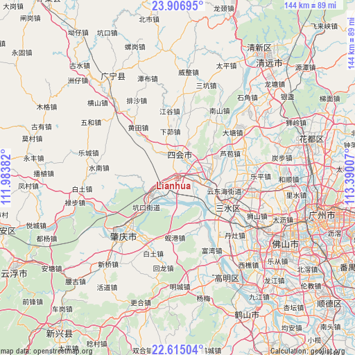
Lianhua GPS coordinates[2]
23° 15' 45.216" North, 112° 41' 12.984" East
| Map corner | latitude | longitude |
|---|---|---|
| Upper-left | 23.90695°, | 111.98382° |
| Center: | 23.26256°, | 112.68694° |
| Lower-right: | 22.61504°, | 113.39007° |
| Map W x H: | 143.6×143.6 km | = 89.2×89.2mi |
| max Lat: | 53.31946° ⇑93.2% North |
| Lianhua: | 23.26256° |
| min Lat: | ⇓6.8% South 18.22056° |
| min Long | Lianhua | max Long |
| 75.07348° | 112.68694° | 134.28917° |
| W 40.8%⇐ | ⇒59.2% E |
Elevation
Elevation of Lianhua is 10 m = 33 ft, and this is 474.8 m = 1558 ft below average elevation for this country.
| Max E: |
5622 m = 18445 ft | 89.9% |
| Avg. | 484.8 m = 1591 ft | |
| Lianhua | 10 m = 33 ft | |
Min E: |
-3 m = -10 ft | 10.1% |
See also: China elevation on elevation.city.
Geographical zone
Lianhua is located in North Torrid zone (between Equator and Tropic of Cancer). Distance of this Northern Tropic circle is 19.4 km =12.1 mi to North.| Distance of | km | miles | from Lianhua |
|---|---|---|---|
| North Pole | 7420.5 | 4610.9 | to North |
| Arctic Circle | 4814.6 | 2991.7 | to North |
| Tropic Cancer | 19.4 | 12.1 | to North |
| Equator | 2586.6 | 1607.2 | to South |


Nearby cities:
15 places around Lianhua: (largest is in red/bold)
• Chengzhong
8.7 km =5.4 mi,  0°
0°
• Dasha
6 km =3.7 mi,  105°
105°
• Dongcheng
8.8 km =5.5 mi,  23°
23°
• Fenghuang
13.9 km =8.6 mi,  242°
242°
• Guangli
11.4 km =7.1 mi,  222°
222°
• Guicheng
14.3 km =8.9 mi, 236°
• Jinli
22.4 km =13.9 mi,  155°
155°
• Kengkou
17.9 km =11.1 mi,  227°
227°
• Longfu
10.8 km =6.7 mi,  11°
11°
• Shapu
10.9 km =6.8 mi,  185°
185°
• Shigou
16.8 km =10.4 mi,  315°
315°
• Xiamao
17.6 km =10.9 mi,  350°
350°
• Xinan
18 km =11.2 mi,  126°
126°
• Yong’an
9.3 km =5.8 mi,  178°
178°
• Zhenshan
8.2 km =5.1 mi, 351°
Sources, notices
• [Note1] Compared only with cities in China existing in our database
• [Src1] Map data: © OpenStreetMap contributors (CC-BY-SA)
• [Src2] Other city data from geonames.org with taken over terms of usage.
• [Src3] Geographical zone / Annual Mean Temperature by Robert A. Rohde @ Wikipedia
