Dasha geodata
Dasha (Guangdong) is a seat of a fourth-order administrative division; located in China in Asia/Shanghai (GMT+8) time zone. In our database, there are 1268 cities with bigger population. Compared to other cities in China, 93.3% of cities are located further ↑North; 58.9% of cities are located further →East and 94.3% of cities have higher elevation than Dasha. Note1


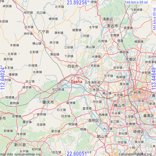
Dasha GPS coordinates[2]
23° 14' 53.16" North, 112° 44' 36.096" East
| Map corner | latitude | longitude |
|---|---|---|
| Upper-left | 23.89256°, | 112.04024° |
| Center: | 23.2481°, | 112.74336° |
| Lower-right: | 22.60051°, | 113.44649° |
| Map W x H: | 143.7×143.7 km | = 89.3×89.3mi |
| max Lat: | 53.31946° ⇑93.3% North |
| Dasha: | 23.2481° |
| min Lat: | ⇓6.7% South 18.22056° |
| min Long | Dasha | max Long |
| 75.07348° | 112.74336° | 134.28917° |
| W 41.1%⇐ | ⇒58.9% E |
Elevation
Elevation of Dasha is 7 m = 23 ft, and this is 477.8 m = 1568 ft below average elevation for this country.
| Max E: |
5622 m = 18445 ft | 94.3% |
| Avg. | 484.8 m = 1591 ft | |
| Dasha | 7 m = 23 ft | |
Min E: |
-3 m = -10 ft | 5.7% |
See also: China elevation on elevation.city.
Geographical zone
Dasha is located in North Torrid zone (between Equator and Tropic of Cancer). Distance of this Northern Tropic circle is 21 km =13 mi to North.| Distance of | km | miles | from Dasha |
|---|---|---|---|
| North Pole | 7422.1 | 4611.9 | to North |
| Arctic Circle | 4816.2 | 2992.6 | to North |
| Tropic Cancer | 21 | 13 | to North |
| Equator | 2584.9 | 1606.2 | to South |


Nearby cities:
15 places around Dasha: (largest is in red/bold)
• Chengzhong
11.7 km =7.3 mi,  331°
331°
• Dongcheng
9.9 km =6.2 mi,  347°
347°
• Fenghuang
18.7 km =11.6 mi,  254°
254°
• Guangli
15.1 km =9.4 mi,  243°
243°
• Guicheng
18.8 km =11.7 mi, 250°
• Jinli
19.2 km =11.9 mi,  169°
169°
• Lianhua
6 km =3.7 mi,  285°
285°
• Longfu
12.7 km =7.9 mi,  343°
343°
• Lubao
19.5 km =12.1 mi,  53°
53°
• Sanshui
18.4 km =11.4 mi,  124°
124°
• Shapu
11.4 km =7.1 mi,  216°
216°
• Xinan
12.5 km =7.8 mi,  136°
136°
• Xinan
18.5 km =11.5 mi, 124°
• Yong’an
9.5 km =5.9 mi, 216°
• Zhenshan
12 km =7.5 mi,  324°
324°
Sources, notices
• [Note1] Compared only with cities in China existing in our database
• [Src1] Map data: © OpenStreetMap contributors (CC-BY-SA)
• [Src2] Other city data from geonames.org with taken over terms of usage.
• [Src3] Geographical zone / Annual Mean Temperature by Robert A. Rohde @ Wikipedia
