Gonghe geodata
Gonghe (Yunnan) is a seat of a third-order administrative division; located in China in Asia/Shanghai (GMT+8) time zone. In our database, there are 1268 cities with bigger population. Compared to other cities in China, 85.3% of cities are located further ↑North; 93.4% of cities are located further →East and 93.7% of cities have lower elevation than Gonghe. Note1


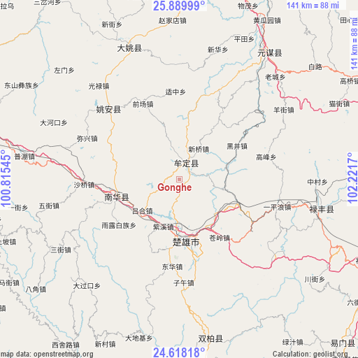
Gonghe GPS coordinates[2]
25° 15' 20.7" North, 101° 31' 6.852" East
| Map corner | latitude | longitude |
|---|---|---|
| Upper-left | 25.88999°, | 100.81545° |
| Center: | 25.25575°, | 101.51857° |
| Lower-right: | 24.61818°, | 102.2217° |
| Map W x H: | 141.4×141.4 km | = 87.9×87.9mi |
| max Lat: | 53.31946° ⇑85.3% North |
| Gonghe: | 25.25575° |
| min Lat: | ⇓14.7% South 18.22056° |
| min Long | Gonghe | max Long |
| 75.07348° | 101.51857° | 134.28917° |
| W 6.6%⇐ | ⇒93.4% E |
Elevation
Elevation of Gonghe is 1811 m = 5942 ft, and this is 1326.2 m = 4351 ft above average elevation for this country.
| Max E: |
5622 m = 18445 ft | 6.3% |
| Gonghe | 1811 m 5942 ft | |
| Avg. | 484.8 m = 1591 ft | |
Min E: |
-3 m = -10 ft | 93.7% |
See also: China elevation on elevation.city.
Geographical zone
Gonghe is located in North temperate zone (between Tropic of Cancer and the Arctic Circle). Distance of this Northern Tropic circle is 202.3 km =125.7 mi to South.| Distance of | km | miles | from Gonghe |
|---|---|---|---|
| North Pole | 7198.9 | 4473.2 | to North |
| Arctic Circle | 4593 | 2854 | to North |
| Tropic Cancer | 202.3 | 125.7 | to South |
| Equator | 2808.2 | 1744.9 | to South |


Nearby cities:
15 places around Gonghe: (largest is in red/bold)
• Dengzishan
66.3 km =41.2 mi,  126°
126°
• Dongchuan
34 km =21.1 mi,  316°
316°
• Jinbi
53.6 km =33.3 mi,  340°
340°
• Jincheng
92.7 km =57.6 mi,  72°
72°
• Jinshan
60.4 km =37.5 mi,  105°
105°
• Liujie
86.3 km =53.6 mi,  124°
124°
• Longchuan
24.9 km =15.5 mi,  245°
245°
• Longquan
91.7 km =57 mi,  135°
135°
• Lubiaojie
81.7 km =50.8 mi, 112°
• Tongchang
79.6 km =49.5 mi, 139°
• Tuguan
76.8 km =47.7 mi, 116°
• Tuodian
66.5 km =41.3 mi,  169°
169°
• Xiaojie
75.8 km =47.1 mi, 125°
• Yongding
88.9 km =55.2 mi,  10°
10°
• Yuanmou
61.2 km =38 mi,  35°
35°
Sources, notices
• [Note1] Compared only with cities in China existing in our database
• [Src1] Map data: © OpenStreetMap contributors (CC-BY-SA)
• [Src2] Other city data from geonames.org with taken over terms of usage.
• [Src3] Geographical zone / Annual Mean Temperature by Robert A. Rohde @ Wikipedia
